
A Landscape Design for Bioenergy Cropping Options
Need for a Landscape Design
The proposed vast increase in bioenergy usage and production will have interdependent environmental and socioeconomic impacts. Several technological pathways connect the various biomass sources to diverse forms of bioenergy (fuels, heat, and power). Currently, the complexity and scale dependency of such decisions and their impacts are not understood, defined, or described with adequate clarity to enable policy makers to develop strategies to ensure a sustainable bioenergy future with acceptable environmental and socioeconomic consequences, particularly under a changing climate regime.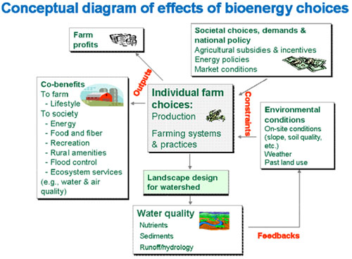
The Approach
We are developing an approach that considers how interventions and conditions at different spatial scales can affect outcomes and to demonstrate how this approach addresses the questions of biofuel selection and deployment. These objectives are being addressed via three tasks: (1) Development of a systems-based conceptual model of the key environmental implications of bioenergy choices, (2) Development of a geospatial information systems framework where the conceptual model can be implemented, and (3) Identification of susceptible points in the conceptual model via spatial optimization.Modeling Implications of Landscape Designs
A spatial optimization model (SOM) has been developed that optimizes land-use decisions within a watershed. The SOM efficiently distributes where dedicated energy crops should be grown while maximizing profits (or minimizing costs) while maintaining water quality limits (nitrogen, phosphorous and sediment concentrations) and acceptable land-use displacement (e.g., area of forest, cropland, and pastured converted to energy crops). These metrics were selected from the conceptual model to represent sustainability issues and farmer choices. The SOM is parameterized using SWAT; this integration combines the decision-making power of an optimization model (i.e. SOM) with advanced non-linear watershed simulation tool (i.e., SWAT). The SOM linked to SWAT is being used to test the implications of different landscape deign choices on select ecosystem services.For more information, contact:
Virginia Dale (dalevh@ornl.gov, 865-576-8043)