
|
CERULEAN WARBLER HABITAT MODEL |
THE MODEL
We used a hybrid of inductive and deductive approaches for predicting potential cerulean warbler (Dendroica cerulea) nesting habitat (Fig. 1). Our approach combined known nesting locations, remote imagery, information from the literature, land cover data, and soil survey interpretations.
We deduced that the tall trees required by cerulean warblers would only be found on soils with adequate depth and moisture. Soil site index, which is the height that a mature tree of a given species will reach by age 50, provides an integrated index of rooting depth, soil moisture, and fertility. Soils in moderate to low productivity classes generally have site indexes insufficient to produce the tall trees required by cerulean warblers. Sites in woodland suitability classes 1, 2, and 3 generally have a hardwood site index of more than 18 m (59 ft) in uplands and more than 24 m (79 ft) in bottom lands. Most of the forested soils on uplands and in valleys at Fort Knox were in these high suitability classes, and could produce trees tall enough to be cerulean warbler habitat. Stand age data were not available for the prediction.
Soils deemed unlikely to support taller trees included severely-eroded Beasley silt clay loam on 6-20% slopes (BfC3, BfD3), severely eroded Eden flaggy silty clay on 20-30% slopes (EdE3), Garmon silt loam on 25-60% slopes (GmE), and soils mapped as complex mixtures of Caneyville, Faywood, Cynthiana, Fairmount, and Woolper series (Cb, Cn, Fl, Fn). Soils identified as potentially suitable were then compared with deciduous forest land cover. Pixels with either unsuitable land cover or unsuitable soil types were eliminated. Only deciduous forest was considered potentially suitable land cover. This intersection produced a prospective cerulean warbler habitat model from the deductive line of reasoning.
During an Endangered Species Survey of Fort Knox, White et al. (1994) identified spatial coordinates for three locations and two transect endpoints where cerulean warblers were seen or heard in the field during the breeding season (603250E, 4203000N; 607900E, 4202700N; 600625E, 4201875N; 586200E, 4200500N; 585500E, 4203225N meters, UTM Zone 16). A spectral signature was developed for these known locations and the eight cells surrounding them. Cells with less than 5% probability of being correctly assigned to cerulean warbler habitat were defined as non- habitat, and the maximum likelihood algorithm was used to classify the LANDSAT TM image using the signature for these two classes. The deductive edaphic/land cover approach was intersected with the inductive extrapolation of known field sites, and only areas common to both approaches were included in the final potential Cerulean warbler habitat map.
MODEL TESTING
Because the impact area is only open to Army personnel, it was excluded from the field testing. Field testing was restricted to points within a 50 m buffer on either side of roads to maximize the number of points visited. Points of each habitat and land cover type were selected randomly within the road buffers. Map-directed assessment of accuracy is a more stringent test than field-directed assessments, in which field crews select points for testing. Choices made in the field are likely to favor the centers of large, homogeneous, representative examples of a particular cover type, whereas random selection from the map may choose test points along edges or isolated small islands of cells.
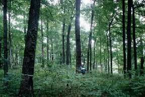
At each point, field teams obtained a location from a portable Global Positioning System (GPS) unit, determined the land cover type of the 20m pixel in which they were located, and noted whether or not each habitat type was present. Field accuracy assessment was done blind; the field teams did not know which land cover category or habitat type had been predicted for the point. Photos were taken at each field site. Each team collected at least 20 position fixes, once every 10 seconds, at each point location. GPS locations were differentially corrected against a base station at the University of Kentucky, Louisville. Predicted tank movement/training areas were not included in the field tests, since they were predicted only to gauge their potential impact on the other habitats.
To ensure that all field teams had a common perception of the habitat and land cover types, all teams were trained using examples during the first field day. In addition, a set of key criteria were used as a litmus test for recognizing each habitat type during the accuracy assessment.
Overall accuracy of the cerulean warbler habitat model was 83% (Table 1). Of 23 sites where the model predicted cerulean warbler habitat, field observations confirmed only 2, for a producer's accuracy (Congalton 1991) of 8.7% (Table 1). Of the five sites where field observation suggested the presence of cerulean warbler habitat, the model predicted only 2, for a user's accuracy (Congalton 1991) of 40% (Table 1).
Despite the relatively low producer's and user's accuracies for habitat predictions, the model is still useful for predicting where habitat does NOT occur (producer's accuracy 97%, user's accuracy 85%; Table 1). This is important to land managers because it allows them to eliminate large areas and focus monitoring and management actions on smaller areas where the probability of finding suitable habitat is greatest.
For further information contact Bill Hargrove or Tom Ashwood
Congalton, R. G. 1991. A review of assessing the accuracy of classifications of remotely sensed data. Remote Sensing and the Environment 37:35–46.
White, D., B. Palmer-Ball, Jr., and R. R. Cicerello. 1994. An Endangered Species Survey of the Fort Knox Military Reservation, Kentucky (January 1994). Kentucky State Nature Preserves Commission, Frankfort, KY.
Return to the top of this page