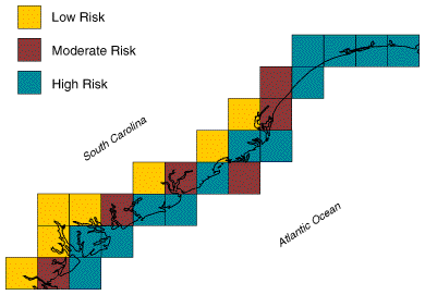

Different levels of risk for hazards associated with sea-level rise are
identified along the South Carolina coast.

How are areas at risk to inundation and increased erosion hazards associated with sea-level rise identified?

Four databases have been developed to help identify coastal areas at risk to inundation and increased erosion hazards in the United States. One contains climatic data on the intensity and frequencies of storms that may affect the coastal zone. The others contain data on more than 22 land and marine variables for the U.S. East, Gulf, and West coasts.
These databases have been used to study and assess both the erosion and permanent or episodic inundation potential of storm-induced or climate change increases in sea level. These assessments were designed to be used by regional planners for the identification of high-risk areas for more detailed study. Areas at risk were identified using a "coastal vulnerability index," which weighted 7 to 13 variables according to the perceived importance of each in determining the relative vulnerability of an area to sea-level rise.
Completed analyses for the U.S. East and Gulf coasts identified the U.S. Southeast as one of the most vulnerable regions. The Southeast, which extends from the Virginia and South Carolina border to the Texas and Mexican border, contains 85% of the U.S. coastal wetlands and 50% of the barrier islands. Of the region's 34,000 km of coastline, more than 40% has been identified as being at high risk to episodic and permanent increases in sea level.

Gornitz, V. M. and T. W. White. 1994. A Coastal Hazards Data Base for the U.S. West Coast. NDP-043C. Oak Ridge National Laboratory, Oak Ridge, Tenn. (in press).
Gornitz, V. M. and T. W. White. 1994. A Coastal Hazards Data Base for the U.S. Gulf Coast. ORNL/CDIAC-60, NDP-043B. Oak Ridge National Laboratory, Oak Ridge, Tenn.
Gornitz, V. M. and T. W. White. 1992. A Coastal Hazards Data Base for the U.S. East Coast. ORNL/CDIAC-45, NDP-043A. Oak Ridge National Laboratory, Oak Ridge, Tenn.
Daniels, R. C. and K. R. Birdwell. 1991. A storm climatology database with applications in regional and global change studies. Bulletin of the American Meteorological Society 72:1005- 1007.
Integrated Assessment Briefs. 1995. ORNL/M-4227. Oak Ridge National Laboratory, Oak Ridge, TN.