 Africa present-potential vegetation
an INQUA Terrestrial Carbon Commission resource
Estimates of preanthropogenic carbon storage in global ecosystem types.
Compiled by Jonathan Adams, Environmental Sciences Division, Oak Ridge National Laboratory, TN 37831, USA
Link to Introduction to the carbon storage inventory
References directly cited in these pages (does not at present include secondary citations)
This section of the inventory aims to give information and opinion on per-unit-area carbon storage for specific ecosystem types in their 'natural', relatively non-anthropogenic state such as existed up until the mid-Holocene in many areas. Under each broad ecosystem type the present range of opinion is discussed, and a 'recommended' value is put forward. The recommended value is that which, on the grounds of this discussion and repeated checking with authors, is suggested by the present author as being the most plausible for the preagricultural/Late Quaternary state of each biome. Note that the purpose here is not to estimate 'present actual' (i.e. 1997) carbon storage, but instead the most likely state at various times in the prehistoric past. This is a state that present-day areas of anthropogenically disturbed ecosystems may tend to return to (even with climatic changes and alterations in the natural disturbance regime) if they are left unmanaged over future decades and centuries. Such estimates are important, therefore, in understanding the future potential fluxes of carbon into terrestrial biomes; they need to be taken into account in the carbon budgeting of planting and forest management policies, in long-term planning of fuelwood resources, etc.
Units
Units are presented here in tonnes of carbon per hectare (t/ha C). This unit is standard in the forestry and forest ecology literature, and is also often used in ecology in general. For conversion into Kg/m2 (a unit quite widely used in soil carbon studies, and in non-forest vegetation carbon studies), divide by 10.
Ecosystem components
For each ecosystem category, the values are broken down as follows; litter and debris (dead trees, dead roots, fallen wood, dead fallen leaves and twigs) t/ha C, vegetation (leaves, stems, trunks, branches, roots) t/ha C, and soil (organic matter below the litter layer and excluding living or dead roots and underground stems) t/ha C.
Each of the vegetation types is described in relation to categories used in the Olson et al. (1983) ecosystems map, although many modifications to this framework have been necessary.
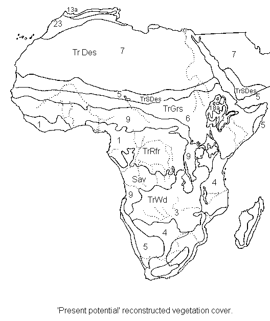
Maps of hypothetical potential ecosystem distribution for present climates in the absence of anthropogenic disturbance (compiled by Jonathan Adams from a range of sources).
Africa present-potential vegetation
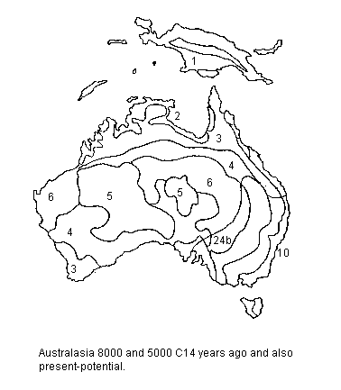 Australasia present-potential vegetation
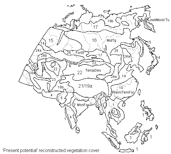 Eurasia present-potential vegetation
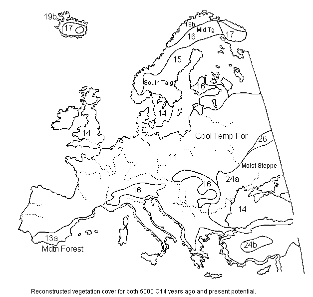 Europe present-potential vegetation
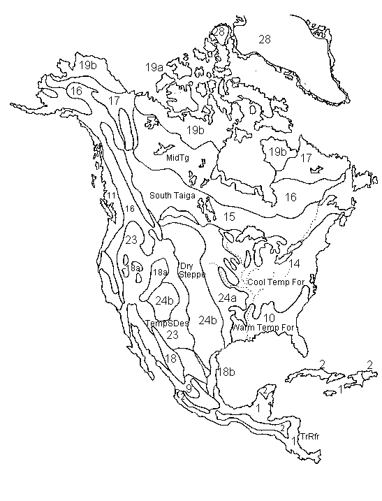 North
& Central America present-potential vegetation
North
& Central America present-potential vegetation
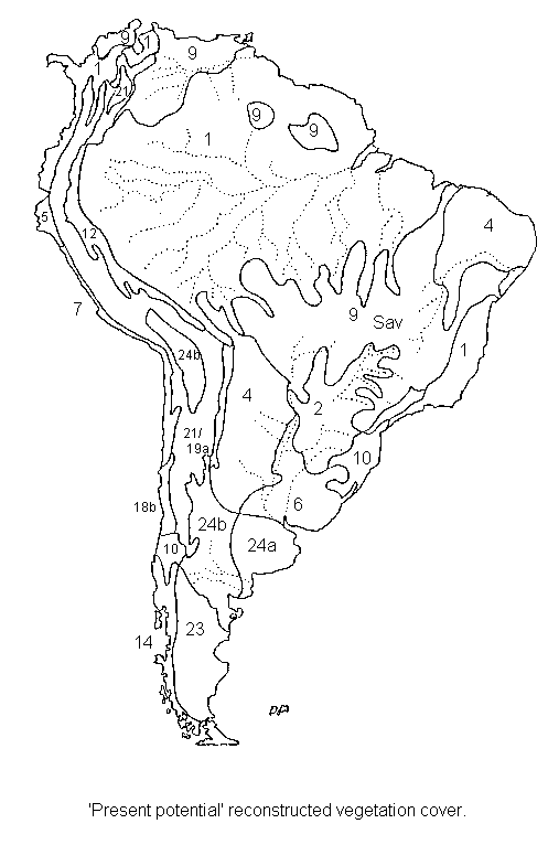 South
America present-potential vegetation
South
America present-potential vegetation
Key to the vegetation classification system used in this inventory and in the above maps
Link to Olson et al.'s map of present-actual ecosystem distribution and carbon storage
Version of the Olson et al. map with 'zoom-in' option
WCMC's map of present-actual global forest distribution
Key to the vegetation classification system used in this table and in the above maps
A summary of suggested average carbon storage in preanthropogenic ('prehistoric') ecosystems. Note that modern-day ecosystems are often depleted in carbon relative to this reconstructed state, due to agriculture and wood-cutting. An error range of approximately +/- 30% is suggested on each value.
| Ecosystem type | Vegetation tC/ha | Soils tC/ha | Litter/Debris tC/ha | Total tC/ha | |
| 1. Tropical Rain Forest | 210 | 100 | 10 | 320 | |
| 2. Monsoon Forest | 150 | 100 | 10 | 260 | |
| 3. Tropical Woodland | 85 | 70 | 10 | 165 | |
| 4. Tropical Thorn Scrub | 40 | 21 | 4 | 65 | |
| 5. Tropical Semi-Desert | 5 | 14 | 0 | 19 | |
| 6. Tropical Grassland | 12 | 42 | 0 | 54 | |
| 7. Tropical Desert | 1 | 0 | 0 | 1 | |
| 8. Savanna/Forest Mosaic | |||||
| 9. Tropical Savanna | 35 | 55 | 0 | 90 | |
| 10. Warm Temperate Forest | 190 | 145 | 36 | 371 | |
| 11. Giant Conifer Forest | 350 | 256 | 120 | 726 | |
| 12. Tropical Montane Forest | 130 | 130 | 15 | 275 | |
| 13a) Mediterranean Forest | 100 | 80 | 8 | 188 | |
| 13b) Mediterranean Scrub | 40 | 60 | 5 | 105 | |
| 14. Cool Temperate Forest | 160 | 140 | 25 | 325 | |
| 15. Southern Taiga | 140 | 135 | 15 | 290 | |
| 16. Main Taiga | 82 | 219 | 15 | 320 | |
| 17. Open Boreal Woodland | 50 | 129 | 15 | 194 | |
| 18a) Temperate Woodland | 95 | 97 | 15 | 207 | |
| 18b) Temperate Scrub | 45 | 45 | 5 | 95 | |
| 19a) Montane/Dry Tundra | 5 | 50 | 0 | 55 | |
| 19b) Lowland Tundra | 10 | 210 | 0 | 220 | |
| 20a) Steppic Steppe-tundra | 5 | 55 | 0 | 60 | |
| 20b) Tundric Steppe-tundra | 5 | 55 | 0 | 60 | |
| 21. Polar/Montane Desert | 1 | 0 | 0 | 1 | |
| 22. Temperate Desert | 1 | 0 | 0 | 1 | |
| 23. Temperate Semi-Desert | 4 | 56 | 0 | 60 | |
| 24a) Moist Steppe | 10 | 250 | 0 | 260 | |
| 24b) Dry Steppe | 6 | 70 | 0 | 76 | |
| 25. Forest Steppe | 10 | 220 | 11 | 241 | |
| 26. Forest-Tundra | 11 | 166 | 20 | 197 | |
| 27. Bog/Swamp | 20 | N.A. | 0 | 20 (+ peat) |