"Who the heck is this Jonathan Adams, anyway?"
Submitted to Environmental Management, January 1998.
Jonathan M. Adams, MS 6335, Environmental Sciences Division, Bldg 1000, Oak Ridge National Laboratory, Oak Ridge, TN 37831, USA.
Abstract
Understanding of global ecological problems is at least partly dependent on clear assessments of vegetation change, and such assessment is always dependent on the use of a vegetation classification scheme. Use of satellite remotely sensed data is the only practical means of carrying out any global-scale vegetation mapping exercise, but if the resulting maps are to be useful to most ecologists and conservationists, they must be closely tied to clearly defined features of vegetation 'on the ground'. Furthermore, much of the mapping which does take place involves more local-scale description of field sites; for purposes of cost and practicality, such studies usually do not involve remote sensing using satellites. There is a need for a single scheme which integrates the smallest to the largest scale in a way that is meaningful to most environmental scientists.
Existing schemes are unsatisfactory for this task; they are ambiguous, unnecessarily complex, and their categories do not correspond to 'common sense' definitions. In response to these problems, a simple structural-physiognomically based scheme with 22 fundamental categories is proposed here for mapping and monitoring on any scale, from local to global. The fundamental categories each subdivide into more specific structural categories for more detailed mapping, but all the categories can be used throughout the world and at any scale, allowing intercomparison between regions.
The next stage in the process will be to obtain the views of as many people working in as many different fields as possible, to see whether the proposed scheme suits their needs and how it should be modified. With a few modifications, such a scheme could easily be appended to an existing land cover classification scheme, such as the FAO system (in press), greatly increasing the usefulness and accessability of the results of the landcover classification.
Table 1. Generalised (1st level) version of the scheme
Fig. 3. Summary of the components of the proposed scheme
The present situation
The need for global mapping and monitoring. Vegetation is a fundamental aspect of the environment; plants and animals live in it, it provides fuel and food for humans, and it has a crucial influence on runoff, albedo, evapotranspiration and ultimately atmospheric composition and global climate. Thus, mapping and monitoring of vegetation provides part of the basis for understanding the world around us, and for recognising environmental problems and their solutions.
Although any vegetation classification is a simplifiction of a complex reality of gradients and mosaics in vegetation (Whittaker 1970), this process of abstraction is necessary to provide a basis to work from. If the vegetation scheme only allows its users to perform tasks with difficulty or ambiguity, it will hinder understanding of these ecological processes and problems (Adams 1996). As Celso (1992) has remarked, perhaps the greatest obstacle to effective environmental protection is the lack of solid information. This may be as true of issues relating to vegetation as of any other aspect of the environment. In an article in New Scientist, Pearce (December, 1992) pointed out that the recent expensive and embarassing confusion over monitoring desertification may be partly due to the lack of any good widely accepted method of classifying vegetation in semi-arid regions.
The nature of the problem. Despite the urgent need to monitor and understand global ecological processes, we do not have the most basic of tools to do the task properly; a good, workable global vegetation scheme that is widely accepted and used.
There are various underlying problems with the current situation in global vegetation mapping and monitoring (Adams 1996), but there is one very fundamental difficulty which in itself calls for a drastic reassessment; there are just too many schemes. A small sample of widely known vegetation schemes includes the following: Braun-Blanquet (1965), Fosberg (1961), IUCN (1973), IUCN (1990), Kuchler (1967), Koppen (1936), Mueller-Dombois (1984), NCC (1988), Nemani & Running (1997), Olson et al. (1983), Walter (1973), White (1983), Whitmore (1984), Tahktajan (1973), UNESCO (1973) and UNESCO (1983). Each of these uses or proposes a distinct vegetation scheme, and each one is used to gather data for its own purposes in a way which tends to be incompatible with the others. It is like the mythical Tower of Babel; everyone is working hard but they are all speaking different languages. The result is confusion, and a great deal of duplicated and wasted effort. A glance at several different sets of recent vegetation maps published for the world or for any particular part of the world will show that although they share broad features in common, there are very considerable differences between the areas of vegetation types which have the same or similar names. These differences cannot simply be put down to inaccuracies in the mapping process itself; they represent very different perceptions of what each particular vegetation 'type' looks like.
The progress that has been made so far is despite the large number of schemes, not because of them. If vegetation science is to make the greatest progress, it will be necessary to pull together the necessary quality of data for a true global or regional overview of the conservation and environmental situation, and to do this it is necessary to start speaking the same language by adopting a universal scheme. At present within the global monitoring community, there are attempts to harmonize monitoring efforts by searching for ways in which the categories used by different schemes overlap with one another, for cross-comparison of data (M. Collins pers. comm.). This is a useful approach for making the most of data which have already been gathered, but it is a remedial excercise which does not tackle the true problem.
It may seem strange to suggest (as this paper does) that one can solve the problem of too many schemes by adding another; many of those who proposed vegetation schemes in the past must have hoped that theirs would be the scheme that everyone would adopt, thereby sorting out the confusion. In order to avoid merely adding another one to the heap, there is a need for a careful and fundamental re-think of what vegetation schemes are for and what they are to be made up of.
Examination of existing published vegetation schemes suggests that they all fail to fulfil the fundamental objectives required for a widely adopted, useful vegetation scheme. A detailed survey of existing published schemes by Adams (1993) shows that they all suffer from one or more of a diverse range of faults which are likely to impede their usefulness and widespread adoption. These include; use of vague definitions to demarcate vegetation types, use of obscure or difficult to use characters in demarcating vegetation, excessive numbers of categories in the top level of the scheme, and failing to include the most widely used and recognized categories. A more detailed account of the problems with existing schemes can be found in Adams (1993, 1996), but a few general points will be made here. As an example of the excessive complexity of some schemes, the UNESCO (1973) scheme (and related UNESCO schemes) consists of hundreds of local scale subdivisions with no emphasis on describing and mapping the important regional and global scale differences. Complex combinations of characters with such terms as 'often' and 'sometimes' are used, and combined with the large numbers of categories the result is a confusing overload of information. The landcover classifications advocated by FGDC (1998) for North America, and Klemas et al. (1992) and Dodson et al. (1995) for coastal zones, use a vegetation cover system based the UNESCO schemes, with the attendant drawbacks (note that while they are used to define 'landcover' and not 'vegetation', the aim and potential range of uses are basically similar and the distinction seems more semantic than practical). The recently published FAO land cover scheme (in press) seems to suffer to some extent from similar problems; the reader is presented with a confusing array of many subdivisions without being guided to familiar named categories such as 'tropical rain forest' or 'steppe'. Although the FAO scheme does include more strongly quantified definitions, it does not seem to go far enough, leaving such ambiguities as where to define the cut-off-point for the 'canopy' (an ambiguous feature in many forest ecosystems), and how to define seperate 'strata' within the vegetation.
As a further example of the unfortunate vaugeness which is integral to existing schemes, the recently published scheme by Nemani & Running (1997), while using many precisely defined characters such as leaf area index and temperature, does not specify a particular way of defining the position of a vegetation boundary along a gradient; forest consisting of long-lived and deciduous canopies is distinguished, but there is no suggestion of what one should do in a forest that consists (for example) 45% of evergreens, 55% of deciduous trees. And what if the canopy is deciduous but the understory is evergreen? Similarly, average leaf lifetime is used in this definition; yet there are surely many places where the average leaf lifetime is not at all evident, and where it changes in a mosaic fashion with the varying proportions of different species in the forest canopy or grassy sward. In Nemani & Running's scheme, the aboveground vegetation is defined as either perennial or annual, with no precisely defined way of coping with the broad transition zones and mosaics which grade between these types. In nature, gradients and mosaics are the rule, not the exception, but the scheme does not recognize this fundamental fact! A lack of attention to how boundaries between vegetation types are defined is a feature of all previous schemes to some extent, although some suffer from this problem more than others. A scheme which suffers from large ambiguities is unfortunately impossible to use consistently in different parts of the world and by different groups, and thus there is no reason for it (or its mapped products) to be widely adopted and used by environmental scientists.
Another problem with existing schemes is the use of characters which do not fit the 'commonsense' definitions of vegetation which exist in a poorly defined form among environmental scientists. For example, by using LAI as a fundamental characteristic, the scheme of Nemani & Running cuts itself off from the 'everyday' world of foresters and conservationists, where LAI at a particular site can only be measured directly by laborious work over weeks or months (and thus has little everyday meaning), unlike canopy cover of a small patch of forest which can be assessed in minutes, by eye. LAI is a feature that has real meaning only when seen from a distance through a spectrophotometer; as such it should probably not be used as a 'core' character of vegetation as it does not correspond directly to the definitions accepted by end users on the ground (note that LAI will still be very important in any remotely sensed mapping process; but it should simply be an indirect indicator of generally accepted 'standard' structural categories which more closely approximate to the vegetation categories percieved by end users).
My intention here in singling out Nemani & Running's scheme is not to condemn it, rather to highlight that it can only be used for a relatively restricted set of purposes. As Nemani & Running emphasize, their scheme is intended to provide a rapid ad hoc background in monitoring global vegetation. For a scheme which offers a more careful and rigorous look at vegetation on any scale, there will have to be clearer reference made both to more traditional and more clearly quantitatively defined characters of vegetation.
Mucina (1997) has pointed out that clear, sharp boundaries in vegetation classifications are not always desirable, and in some circumstances fairly loose 'fuzzy' categories that allow for the natural blending of vegetation types may be appropriate. However, this is probably more the exception than the rule. It is my contention that most environmental scientists would at least prefer to have the option of a rigorous scheme to fall back on some of the time, when confusion and ambiguity start to reign. The scheme that is being proposed here in fact has some aspects of the 'fuzzy' classification that Mucina is advocating, and may thus be able to combine the best of both worlds; this scheme suggests use of percentage values and contours to express mosaic inclusions within areas of the 'predominant' vegetation type.
The only way to progress towards a more widely usable and accepted scheme is to carefully draw upon the experience of other vegetation schemes, such as those mentioned above, taking note of their best points and discarding their bad points. It will also be important to consult as wide a range of opinion as possible, making sure that the boundaries used are the most acceptable and useful to those who will hopefully be the users of the scheme. There is a need for a scheme which starts by building on a broader tradition, using 'common sense' categories, and which goes on to be modified and improved by input from a wide range of those who will eventually be involved with mapping, or in using those maps for their own work.
The optimal global vegetation scheme
What general sorts of features should one look for in working towards a better mapping and description scheme, of broad applicability within the environmental sciences? It seems necessary to emphasize at least the following points in designing any such universal vegetation scheme. The following characteristics have been outlined in a recent review by the present author (Adams 1996);
(i) Relying wherever possible on structural-physiognomic characters of vegetation.
(ii) Always clearly defining the limits between vegetation types.
(iii) Relying on factors which are easy to map from the field or indirectly from remote sensing.
(iv) Having enough categories but not so many that it confuses a broadscale overview.
(v) Giving specific guidelines for mapping across mosaics in vegetation
(vi) Providing specific guidelines for defining anthropogenically altered or secondary vegetation.
These features have been central to the design of the new scheme proposed here.
A new proposed scheme
Building upon the recent survey (Adams 1993, 1996) of the current situation in vegetation mapping, this paper suggests the outline of a new vegetation description scheme that combines some of the most useful aspects of other schemes, and adds further improvements that seem appropriate for the range of tasks it is needed for. It is intended to provide a starting point for arriving at a universally agreed standard for vegetation definitions, which mapping efforts at all spatial scales may contribute to.
As the present author (Adams 1996) has already advocated, it will always be necessary for a new scheme to be put forward in the scientific literature for open comment and criticism, before any universally useful scheme can be arrived at. The scheme that is proposed here, prepared by the present author whilst under contract to Mark Collins of the World Conservation Monitoring Centre, is specifically tailored to fit in with broad 'traditions' in vegetation science, but it has also been necessary to depart from these traditions to some extent in order to present what is considered to be a workable system.
Table 1. summary of the proposed WCMC scheme.
Appendix; summary of the proposed WCMC scheme with 2nd level of subdivision.
The use of structural and climatic factors. The proposed WCMC scheme (Table 1) is principally structural-physiognomic in character. The classification system concentrates on the canopy layer of vegetation (Fig.1), often ignoring the understory levels (which generally correlate with the overlying canopy density and other physiognomic patterns) for the sake of simplicity and ease of use. The definitions used are intended to be simple and clear-cut, and are all based on particular quantitative values that interlock with those used in other categories within the scheme. The quantitative factor is intended to narrow down the element of subjectivity in using the definitions, and to focus on aspects of the vegetation which are most likely to be recognizable by inexperienced field observers, and also from aerial photographs and satellite data.
None of the definitions proposed in this scheme is deliberately tied to floristics, although of course there will be a general relationship with such factors as leaf form (e.g. needle-leaved forms tend to be conifers) or deciduousness. Climate is only admitted (in the form of a temperature index) where there does not appear to be any simple and easy-to-use structural factor that follows a broad gradient in vegetation ecology and floristics.
It may seem suprising that no straightforward structural definition could be found for most of the latitudinally-related gradients in vegetation, yet careful thought and extensive consultation with colleagues has failed to yield any such character that seems to adaquately express the nature of these vegetation gradients. For example, whilst one might initially suggest mean leaf size as a simple reliable indicator of rainforest limits, on reflection it soon becomes apparent that this could never work effectively in a simple scheme. Not only is it cumbersome and time consuming to obtain a large enough sample of leaves from a range of canopy tree species for the measure to be effective (although these could be obtained from leaves in the litter layer on the forest floor), but different types of rainforest under distinct soil and disturbance conditions can have very different mean leaf sizes. For instance, young secondary rainforest tends to have leaves which are much larger than in primary rainforest, whilst heath forest has leaves that are much smaller than forest growing on more fertile soils. It would seem unreasonable to most people to have to conclude that because a heath forest has small leaves, it does not count as a rainforest but instead as a temperate forest. One could try to clear up the confusion by introducing special clauses to keep something like heath forest within the limits of rainforest, but then the system loses its origonal simplicity and is in danger of collapsing under its own complexity. One then comes up against the dilemma of whether we should allow more complex structural definitions to creep into the system to describe certain vegetation types that defy simple description. Since the whole object of the exercise has been to eliminate complexity and ambiguity, such a step could be simply self-defeating.
Similarly, it seems that there can be no simple structural definition to distinguish swamp vegetation from non-inundated vegetation, in any way that is satisfactory to delimit the diverse range of this type of inundated vegetation types that exist around the world. Despite the author's reservations about using soil-related characters as part of a global vegetation scheme, it is suggested that one of the most fundamental factors used in the classification should be the division of vegetation types of similar structure into those which grow under inundated and non-inundated soil conditions. This is because the distinction does seem to be a crucial one with respect to vegetation ecology, and it is one which tends to be strongly and reliably related to floristic composition and other characters of conservation importance.
The number of categories. Around 20 categories are proposed for the 'fundamental' (1st) level of the new vegetation scheme, for use at the global and regional level. This small number is intended to cut down the amount of unnecessary information which is presented, instead focusing attention on the broader and more important patterns. A lower-level classification of around 60 categories is suggested (Appendix) for use in studies which require greater ecological or spatial precision. It may also be worthwhile to create a third level, subdividing this still further to give around 200-300 categories. If necessary, specific floristic indicators could be brought in for this lowest level, as the application of these categories would only be on a fairly local scale in any case. It might be useful to begin thinking of a way in which such 'indicator' species could be used in a clearly defined, consistent way (although the much more local scale on which these lowest-level categories are to be used may in itself eliminate much of this problem of inconsistency).
Land use. Also included in this scheme in its present preliminary form is a set of 'historical/land use' categories, such as the distinction between agricultural use and natural or semi--natural vegetation, and secondary vegetation. The agricultural - non-agricultural distinction is dealt with at a fundamental level within the 20 categories because it is an immediate 'here and now' distinction, relevant to every aspect of vegetation science. The more subtle differences between primary vegetation (vegetation not recently severely disturbed by man or by other agencies) and secondary vegetation (vegetation which has been disturbed but is being allowed to regenerate) are left to a series of 'shadow' categories. Rather than using totally subjective and ad hoc definitions of what is or is not secondary vegetation in a particular area, it seems better to set down a set of guidelines to work from. For this reason the author has set out such guidelines to accompany the proposed vegetation scheme (see below). However, even with the underlying basis of such guidelines the actual decision as to the disturbance history of a particular area may eventually have to come down to complex and elusive factors, because the best indicators of history vary strongly from one place to another.
Coastal systems The scheme in its present form does not explicitly deal with coastal vegetation types, and although these occupy a relatively small area of the land surface, they are considered important for many reasons. A single blanket category (easily subdivided) of 'saltwater' vegetation types (receiving brackish or saltwater inundation on a frequent basis) might also be appended to the main scheme of 23 global vegetation types.
Producing modified versions of the scheme. It is inevitable that this suggested scheme will not prove useful for everyone working on vegetation-related proceses. Rather than constructing totally different and incompatible schemes for individual purposes, it is possible that ad hoc modified schemes could also be built onto this global scheme for specific mapping purposes (e.g. an animal ecologist may wish to define an extra cover class for his/her work on a particular nature reserve), but they could refer back to and be inter-compatible with the universal scheme. If those who construct and use such ad hoc schemes clearly state the changes that they have made, there will be less danger of confusing the situation, and both those using the the origonal and modified schemes may still usefully exchange map data with one another.
Practical details on the proposed usage of the scheme.
Names and breadths of categories. Note that the proposed scheme is not totally self-consistent throughout in either the breadths of categories used (e.g. the equivalent savanna and forest in the 'inundated vegetation' category are lumped together as 'swamp woodland'), nor in the naming of categories (cool climates are called 'cool', whereas warm climates are called 'tropical' rather than 'warm'). This is because the tradition of people's thinking and naming of broad vegetation categories is not consistent either; the author has tried to adopt names which sound most natural in usage. Wherever it can, the proposed scheme aims to build upon broad traditions, not bend thinking into a completely different mould.
Sample size.
Because of the universal patchiness in vegetation, some averaging of cover values across a standard sample size will be necessary in any rigorously defined vegetation scheme. For example, if one has clumps of forest covering 50% of an otherwise treeless grassland landscape, should one average over a broad area and say that this is an 'open woodland', or concentrate on the smaller scale and acknowledge it as a mosaic, of patches of dense forest in a grassland? A global scale scheme which is incapable of allowing for this heterogeneity in a way which makes good sense to environmental scientists will fail to be generally adopted. Possibly the most appropriate way of dealing with this is to vary the sample size used for the scheme according to the general spatial scale that one intends to map at. Thus, for global or regional scale mapping a 1 km or even 10 km 'average' might be taken for % cover of forest, of evergreen trees, or grassy cover. This should help minimize problems such as 'how big do the patches of grass in a savanna have to be before they themselves constitute a grassland within a woodland?'. If a 1 km 'sample size' is being used, the answer to this would be 'when the patches of grass reach more than 1km by 1km in dimension'.For a local nature reserve or a small-scale ecological study, a mapping resultion of just 10m or 100m could be used, to show up the important smaller-scale patchiness in vegetation. As long as the spatial scale used for averaging % cover values is clearly specified when the maps or verbal site description is published, there is no possibility of confusion and local and regional scales of mapping can each make useful contributions to one another. To a local study, the region 1km-scale classification provides a 'background', while on a regional scale of mapping a collection of large numbers of 10m-sized samples can provide a useful form of 'ground proofing'.
Coping with mosaics. As noted above, there will often be large patches of vegetation that fall into one class intermixed with patches that fall into another class. It is suggested that these should be dealt with in a way that if the patches are smaller than a certain specified size (see above), they should not be mapped as separate units but merely regarded as a subcomponent of a mosaic.The author suggests that the most appropriate method of dealing with vegetation areas perceived as being mosaic, may be to take the vegetation unit which is most abundant within the mosaic as the named map category for that area, but to acknowledge other minority elements as also being present. This might be done using contours. Thus the vegetation category which covers more than 50% of the area is shown as 'the' vegetation type. The other vegetation type present may be acknowledged with a written symbol, for example there may be a map area defined as savanna, but with '30% grassland'. Dotted lines on the resulting maps could used to define contours of prevalence of the co-occurring vegetation type within the mosaic, say at the 75%, 50% and 25% proportion mixed with patches of the 'predominant' vegetation type.
Explanation of specific headings in Table 1, and their use as part of the scheme;
1. Woody cover at >6m. Imagine a horizontal line or plane at 6m off the ground. What is the % cover of the canopy that sits above that line, casting its shade downwards onto the imaginary plane (see Fig.1)? This is intended as a means of assessing to what extent there is a dense forest-type canopy present. Include woody vines and all types of trees in this assessment, but only the parts of their crowns which are actually at or above the 6m line. This should be done at whatever time of year that the trees or shrubs have the greatest density of leaf cover on them, and the same applies to the other woody cover assessments.
2. Woody cover at 0.6-6m. Again, imagine a horizontal line or plain at 6m off the ground. This time, ignore any canopy cover which lies above the 6m line. Look below the line and imagine the % area covered by the woody plants below this line down to a lower at level 0.6m off the ground. This method is intended to assess the density of the scrub or understory layer of the vegetation.
3. Woody cover >0.6m. Rather than imagining a line at 6m, take all of the woody vegetation above 0.6m, and estimate the % cover that it casts down to this level.
4. Monthly mean temperature, degrees centigrade.
A climatic index is introduced in this scheme because in a global scheme, vegetation types of superficially similar structural appearance can have very different ecological characteristics and conservation relevance according to the climatic realm in which they occur. Despite extensive consultation between this author and colleagues, here appear to be no straightforward structural indicators to divide up these gradients in a way that corresponds to present ecological thinking (e.g. for tropical rainforest vs warm temperate evergreen forest, relatively unbiased frequency-based measurements of incidence of drip tips or leaf size would probably be too complex to be practicable in the field).
The mean daily temperature of the coldest month is intended as a general guideline to the sort of climatic regime that the plants and animals are living under, and hence the sort of ecological behaviour and taxonomic affinities to expect from them. The 15.5 Deg.C mean monthly temperature is used as a boundary for the tropics, following Prentice et al's (1992) discovery that it defines closely the poleward limit of what is generally perceived of (according to the Olson et al. map at least) as tropical forest. The underlying reason for this relationship with plant form and taxonomic composition may relate to the likelihood of occasional frosts in winter. This is for the latitudinal and altitudinal trends, within each broad structural vegetation type, which are caused by temperature gradients. Warmest monthly mean temperatures are also used to delimit polar vegetation types from temperate or boreal ones. Such simple climate limits will not be the sole determaining factor of the limits of vegetation 'types' (as they are perceived in common parlance), which in any case usually grade into one another across a range of climatic values. It is just an ad hoc but fairly meaningful way of drawing a limit (better than having no limit at all, in any case). The positions of the tropical-temperate and other latitudinal boundaries are also varied according to what seem to be the general perceptions of where different vegetation types lie. The temperature limits are used here correspond to these varied and 'messy' inconsistancies in usage, rather than trying to bend usage into fundamentally new moulds.
In this preliminary classification, the author suggests that the same temperature index be used to lump montane vegetation types in with high-latitude vegetation. There are many important differences between an equatorial montane forest and a high-latitude forest, but the aim in this broadest-level classification is to break world vegetation into about 20 very general types. The finer distinctions can be acknowledged in lower-level sub-classes based on this scheme. However, if you think that it is really very important to distinguish tropical montane forest using a different type of definition, please tell the author!
5. % Broadleaved vegetation at >6m. Again, imagine a line at 6m off the ground. What is the relative % cover (taken as a % of the canopy area which is present overall) above that line which consists? In fact, this defininition of broadleaved can include anything that is not narrowly needle-leaved - like a Pinus, Abies or Taxus - or scale-leaved - such as a Casuarina. For finely pinnate-leaved plants, such as Acacia, count the size of the whole botanical leaf structure (not just the individual pinnae), which will make them broad-leaved.
6. % >6m woody vegetation losing leaves. Amongst the cover which is present at above 6m height, what % of the leaves present at the maximum during the year, is lost during the minimum leaf cover time, during an average year? In other words, to what extent is the overall leaf cover deciduous?
7. Grass, low shrub or herbaceous coverage. Assess the % ground cover, over the standard sample area as a whole (be it 10m by 10m, 100m by 100m, or 1 km by 1 km) by herbaceous grasses or other plants (of whatever height), (including mosses and lichens), and by low woody shrubs below a level of 0.6m. The low shrubs are here included with the herbaceous coverage for simplicity of classification; in any case wherever there are low shrubs there are some forbs and grasses present. The cover assessed should be for the time during an 'average' (or 'normal') year at which the coverage reaches its maximum. For arid vegetation which is subject to occasional 'bursts' of plant activity only once every three years or so, then only take the maximum cover which is thought to be is reached during the majority (50% or more) of years.
8. Secondary vs primary vegetation.
This forms a 'ghost' set of categories through the proposed scheme, as a subdivision of each of the fundamental categories (e.g. for Temperate Deciduous Forest there is both a primary and a secondary category within the scheme).
In the field, the distinction between secondary and primary forest depends on a whole array of subtle indicators, that vary from one location to another. Thus it is quite impossible to come up with a global set of 'indicators' for distinguishing secondary from primary vegetation in the field.
A possible, widely acceptable definition to distinguish between primary and secondary vegetation might be; "secondary forest; apparently having largely regenerated from a clear-cutting or similar disturbance event, or from ending of cultivation, within the last 100 years, based on whatever evidence is to hand to compare it with the local primary forest, whether it be structural, floristic or purely historical.". However, wide consultation on this will be necessary in view of the importance to vegetation science of making the distinction. A 100m sampling scale of the disturbance event, in which 90% of more of the origonal vegetation cover was lost, might also be necessary.
Working towards a widely accepted scheme.
There are other practicalities which must be thought through if this scheme (or something like it) is to be properly developed and widely adopted.
The importance of consultation. A crucial step (and one which earlier attempts at producing universal schemes have apparently fallen down on) is to consult with a very wide range those who actually work with vegetation, either as mappers or as users of maps. The author has already begun this task by consulting a number of widely respected vegetation mappers, whose opinions he is very grateful for, and the scheme in its present form has already been modified to take account of the suggestions put forward by these workers. An earlier and very similar form of this scheme has already been presented to a UNEP-HEM / WCMC funded workshop in Charlottesville USA in 1993, at which various helpful perspectives were added. The next stage is the present publication, intended to cast the net wider to provoke discussion and bring in the opinions of a very wide range those who work in all aspects of vegetation science at a variety of scales, and in different parts of the world.
Testing the scheme. A crucial test of this scheme or a modified version of it will be whether it really can be used easily and consistently in the field and (indirectly) from satellite data, for mapping and description of vegetation. Before such a scheme can be officially adopted on a widespread scale, it will eventually be necessary to set up a thorough programme of 'field experiments' whereby groups of users in various parts of the world come together to 'try out' the scheme on the same patch of vegetation to see how consistent their judgements are, and how easily they feel that they can 'get along' with the scheme.
Mapping the world. It is unlikely that the entire world will ever be mapped using a scheme which is as clearly defined in its description as the one proposed here. The necessary funding and expertise to map every last inaccessable portion of tropical swamp, desert or mountain range is unlikely to be available, even if the world's governments take an enlightened attitude towards the task. Even if such total global coverage is eventually achieved, it is likely to take several years if not decades between the first and last sectors of the world map having been compiled, and parts of it will already be significantly out of date.
The acceptance of such difficulties is no reason to call the exercise a waste of time. Even if the coverage is very incomplete, and if the mapping work is done in different decades in different places, it will still be a considerable advance on anything available at the moment. The internal logic of the categories used means that they have potentially great usefulness to vegetation scientists working on even the most parochial scale, but equally on the broadest scale. Furthermore, one does not need complete coverage of a continent, or even a single country or province, before benefits begin to accrue from the ease of cross-referencing information between different areas. Indeed it is likely that the obvious benefits that are seen to result from from such limited cross-comparisons will provide the impetus amongst conserving organizations for spreading the mapping to cover ever-wider areas.
A summary of the message of this paper.
There is much to be gained - and very little to lose - from vegetation scientists adopting a simple universal scheme similar to the one presented here for all or nearly all future efforts to map vegetation. Such a scheme may at first be used for piecemeal mapping studies, and as a focus for converting data from other mapped vegetation studies, but it can also eventually be adopted for a concerted global attempt to take detailed stock of the world's vegetation. Recent landcover classifications such as Klemas et al. (1992) and Dodson et al. (1995), FAO (in press) and FGDC (1998) do not provide a simple unambiguous set of global 'biome' categories, though it would not be difficult to refine and build upon these to arrive at such a classification along the lines suggested here.
A scheme that is very closely related to remote sensing needs, such as that suggested by Nemani & Running (1996), has definite promise as something which can provide a 'quick look' at vegetation on a very broad scale, but a more careful rigorous underpinning of this 'quick look' will also eventually be necessary. It sometimes seems necessary to remind ourselves that mapping of vegetation does not exist for the benefit of the remote sensing community; if remote sensing fails to deliver products which reasonably approximate to the vegetation that environmental scientists percieve and work with on the ground, then it has partly failed in its objectives. Unfortunately, the fulfillment of these objectives - producing maps which have meaning and use to the ecologists, conservationists, foresters etc. - will be much more arduous and expensive than producing maps based only on characters such as Leaf Area Index which are easily to recognize from space. This is unfortunate, but unavoidable. Only when vegetation mapping by remote sensing uses a generally acceptable 'gold standard' of vegetation structure and appearance that has a commonsense meaning on the ground as well as from space, will its products be at their most useful. Remotely sensed characters such as LAI should be used in mapping by remote sensing, but they should be used as an indirect means to identifying structural height and cover values in a scheme that is meaningful and useful to most environmental scientists in most parts of the world.
The author is not suggesting that the scheme presented here is in the exact form in which it should be taken up for this purpose, merely that it provides a basis which may prompt others to work with it and produce modified and improved versions. It is important to remember that there may also be a need for certain other very different schemes to be used for specific purposes, for example in rapid global-scale vegetation monitoring using satellites to detect changes on a timescale of between months and several years (e.g. the scheme of Nemani & Running 1996). The mapping scheme suggested here is intended to provide a solid background of useful information, which other more rapid-timescale monitoring efforts may also be able to tap in to.
There is now a need for further consultation and exchange of views, and for rival 'alternative' schemes to be put forward for comparison. Towards this goal, the author would be grateful for any views or further suggestions on the preliminary vegetation scheme presented here.
Acknowledgements; Many people has already generously taken the time and interest to give their comments on the proposed vegetation scheme, and on my accompanying review of the current situation in vegetation mapping. The author would particularly like to thank Prof. F. Blasco, Prof. Dr. A. Zonnerfeld, Dr R. Leemans, Dr R.J. Whittaker, Dr J.S. Olson, colleagues at WCMC and in the Department of Plant Sciences of the University of Cambridge, the Environmental Sciences Division of Oak Ridge National Laboratory, and all those who attended the UNEP-HEM workshop in Charlottesville Virginia, January 1993. Their helpful suggestions and criticisms have been noted. This work was intiated whilst Jonathan Adams was employed under the supervision of Mark Collins, as a consultant with the World Conservation Monitoring Centre, which is funded by the United Nations Environment Programme, the International Union of Conserving Nations, and the World Wide Fund for Nature. Jonathan Adams is currently supported by the Lockheed-Martin Corporation on a Wigner Fellowship.
References
Adams J.M. (1993). Towards a better vegetation scheme for global mapping and monitoring. Discussion document for UNEP-HEM/WCMC meeting on vegetation mapping, Chalottesville, Virginia.
Adams J.M. (1996). Towards a better vegetation scheme for global mapping and monitoring. Journal of Biogeography/Global Ecology and Biogeography Letters. v.5 p.3-6.
Braun-Blanquet J. (1965). Plant Sociology; The study of plant communities. Hafner publishing Co., London. 439 pp.
Celso C. (1992). Environmental protection: a view from Brazil. p.1079-1080. Environmental Science and Technology v.26.
Dobson, J. E., E. A. Bright, R. L. Ferguson, D. W. Field, L. L. Wood, K. D. Haddad, H. Iredale, III, V. V. Klemas, R. J. Orth, and J. P. Thomas. 1995. NOAA Coastal Change Analysis Proram; Guidance for Regional Implementation Version 1.0, NOAA technical report NMFS 123.
FAO scheme (in press) URL; http://www.fao.org/WAICENT/FAOINFO/SUSTDEV/EIdirect/EIre0019.htm
FGDC Vegetation Scheme (1998). http://biology.usgs.gov/fgdc.veg/
Fosberg R.F. (1961). A classification of vegetation for general purposes. Tropical Ecology. v.2 p.1-28.
IUCN (1973). A working system for the classification of world vegetation. IUCN Occasional Paper No. 5. IUCN, Gland, Switzerland. 21 pp.
IUCN (1990). United Nations List of National Parks and Protected Areas. IUCN, Gland. Switzerland and Cambridge, UK. 284 pp.
Klemas, V. V., J. E. Dobson, R. L. Ferguson, and K. D. Haddad. 1992. "A Coastal Land Cover Classification System for the NOAA Coastwatch Change Analysis Project," Journal of Coastal Research Vol. 9, No. 3.
Kuchler A.W. (1967). Vegetation Mapping. The Ronald Press Company. New York. 472 pp.
Kuchler A.W. & Zonnerveld I.S. (1988) (eds.). Vegetation Mapping. Handbook of Vegetation Science, Volume 10. Kluwer Academic Publishers. 623 pp.
Koppen W. (1936). Das geographisca System der Klimate. In: Kopen W. & Geiger G. (eds), Handbuch der Klimatologie, Vol.1 part 1, part C. Gebr. Borntraeger, Berlin.
Mueller-Dombois D. (1984). Classification and mapping of plant communities: a review with emphasis on tropical vegetation. p. 21-88 in; G.M. Woodwell (ed.) The role of terrestrial vegetation in the global carbon cycle: Measurement by remote sensing. 1984 SCOPE. John Wiley & Sons Ltd.
Mucina L. (1997). Classification of vegetation: Past, present and future. Journal of Vegetation Science v.8 p.751-760.
Nemani R. & Running S.W. (1996). Implementation of a hierarchical global vegetation classification in ecosystem function models. Journal of Vegetation Science v.7 p.337-346.
NCC (1988). National Vegetation Classification. Nature Conservancy Council. Peterborough, UK.
Olson J.S., Watts J.A. & Allinson L.J. (1983) Carbon in Live Vegetation in Major World Ecosystems. Environmental Sciences Division Publication No. 1997. Oak Ridge National Laboratory, Tennessee.
Walter H. (1973). Vegetation of the Earth. Translation from 5th edition in German, by Joy Weiser. Springer-Verlag, Berlin, Hiedelberg, New York, Tokyo. 318 pp.
White F. (1983). UNESCO Vegetation map of Africa. UNESCO, Paris.
Whitmore T.C. (1975). Tropical rainforests of the Far East. Clarendon Press. Oxford. 282 pp.
Whitmore T.C. (1984). A vegetation map of Malesia at scale 1:5 million. Journal of Biogeography. v.11. p.461-471.
Whittaker R.H. (1970). Communities and Ecosystems. Current concepts in Biology Series. The Macmillan Company, London. 162 pp.
Tahktajan A.A. (1973). Origin and distribution of the angiosperms. Academic Press.
UNESCO (1973). International mapping and classification of vegetation. UNESCO Ecology and Conservation Series 6. 93 pp.
UNESCO (1983). Vegetation map of South America. UNESCO, Paris.
generalised (1st level) version of the scheme
You can contact me at: jonathan@elvis.esd.ornl.gov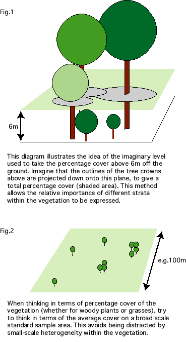