Summary
From around 150,000 to 130,000 years ago, Africa experienced colder and more arid than present conditions. About 130,000 years ago, a warm phase moister than the present began, and this lasted until about 115,000 years ago, with greater rainforest extent and the deserts almost completely covered with vegetation. Subsequent cooling and drying of the climate led to a cold, arid maximum about 70,000 years ago, followed by a slight moderation of climate and then a second aridity maximum around 22,000-13,000 14C years ago. Conditions then quickly became warmer and moister, though with an interruption by aridity around 11,000 14C years ago. A resumption of warm, moist conditions led up to the Holocene 'optimum' of greater rainforest extent and vegetation covering the Sahara. Conditions then became somewhat more arid and similar to the present. Relatively brief arid phases (e.g. 8,200 14C y.a.) appear to punctuate the generally moister early and mid Holocene conditions.
Details of the vegetation categories used in the maps
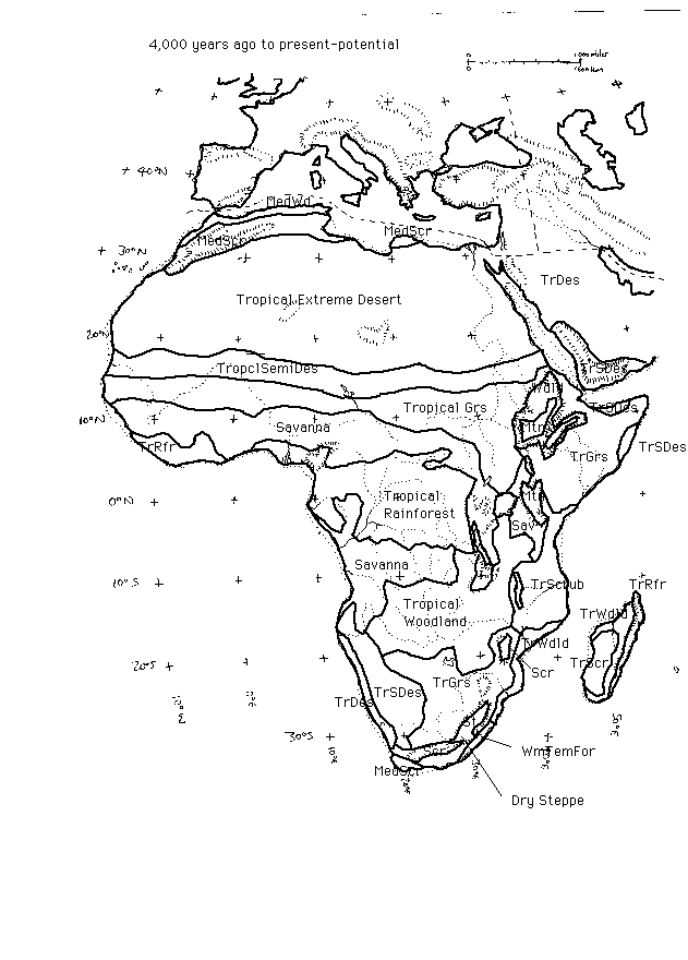 Present-potential vegetation - Africa
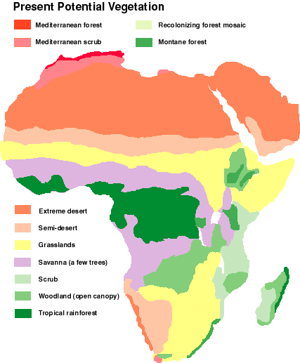 Africa present-potential vegetation
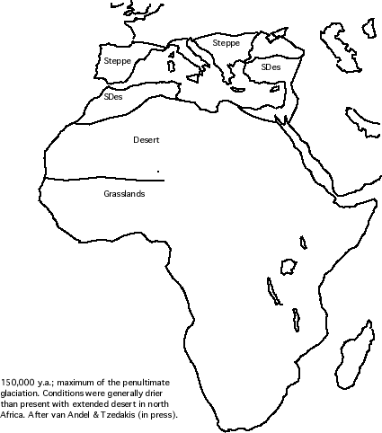
150,000 y.a.; maximum of the penultimate glaciation (oxygen Isotope Stage 6). Conditions were generally drier than present with extended desert in north Africa. After van Andel & Tzedakis (1996).
Approx. 125,000 - 120,000 y.a., moistest phase of the Eemian Interglacial (Isotope Stage 5e). Rainforest occupied a far greater area than at present, and rainfall was generally higher over north Africa. Data are sparse, mainly coming from long cores recording pollen and dust flux off the west coast of Africa. From these indicators, it seems that the situation generally resembled that of the early Holocene, around 8,000 14C y.a. General Eemian 'optimum' conditions in north Africa are summarized in map form by Frenzel et al. (1992) and by van Andel & Tzedakis (1996).
90,000 - 110,000 y.a., an arid phase following the end of the Eemian interglacial. There are indications from the record of desert-dune formation across south-western Africa, that at least part of this phase was extremely arid (Stokes et al. 1997). Desert conditions seem to have existed over a large area west of about 25 deg.E, and south of about 18 deg.S. Whether strong aridity occurred in other parts of Africa at about the same time is unknown, but given the general pattern that prevails later in the Upper Quaternary, this must be considered a strong possibility.
Africa (map in preparation). 65,000 y.a., during part of an intense cold stage between 75,000 & 58,000 years ago (Oxygen Isotope Stage 4). This map is taken from van Andel & Tzedakis (1996), and based on cores off the west coast of Africa. Sea level was about 75m below present level, but the extended coastlines are not shown here. Vegetation conditions seem to have been much as they were at the Last Glacial Maximum (see below), with greater-than-present desert extent in North Africa.
Dry phases across the Northern Monsoon belt
During the period between about 110,000 and 11,000 14C y.a., there was a great deal of variability in climate across the North African region, though conditions were generally drier and cooler than at present.The most intensely dry and cool phases across Northern Africa and Arabia are thought to correspond to cold, ice-rafting phases in the North Atlantic. Given the sparsity of the record from the continent, only a few of these 'Heinrich events' have been shown to correlate with dry phases across the Sahara-Arabia belt, though it is generally thought likely that all or most of them affected the region. Table 1 below shows some major Heinrich events that probably also resulted in particularly extensive aridity and cooler temperatures across the northern monsoon belt.
Table 1 Timing of major Heinrich events during the last 130,000 years (ages in calender years after Bond et al., 1997 for H0- H3; after Bond et al., 1993 for H4- H6). These cold, dry phases in the North Atlantic probably each affected the northern monsoon belt too.
YD or H0 12.2 ka (calendar age)
H1 16.8
H2 24.1
H3 30.1
H4 35.9
H5 50.0
H6 66.0
YD: Younger Dryas
H: Heinrich event
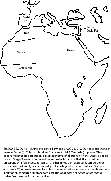
36,000-39,000 y.a; part of the 'middling' phase (Oxygen Isotope stage 3). This time slice constitutes part of the period between 57,000 & 24,000 years ago (Oxygen Isotope Stage 3). The map is taken from van Andel & Tzedakis (1996). This general vegetation distribution is representative of about half of the Stage 3 period overall. Stage 3 was characterised by an unstable climate that fluctuated on timespans of a few thousand years. At other times during Stage 3, temperatures were cooler but aridity was apparently not much greater than present in north Africa. Sea level was about 70m below present level, but the extended coastlines are not shown here. Information comes mainly from cores off the west coast of Africa which record pollen flux changes from the continent.
An extreme, widespread arid event across southern and south-western Africa seems to have occurred around 43,000-40,000 years ago, with extensive dune activity and extreme desert in northern Botswana, possibly extending north to Angola (Stokes et al. 1997, Stokes per. comm. 1997)
Africa during a relatively mild period, around 39,000-36,000 y.a. (no data for most areas)
Lézine & Vernaud-Grazzini (1994) suggest on the basis of core taken to the south off the coast of West Africa, that climate was moister and forest cover more extensive than now before about 22,000 14C y.a. However, in parts of the central and west African rain forest belt, conditions appear to have been somewhat drier than present (Maley 1990, Giresse et al. 1994) although forest cover was still quite extensive. In the eastern highlands of central Africa, conditions might have been somewhat moister than at present, according to pollen evidence from swamps in Rwanda (Lowe & Walker 1984). In a departure from this general picture, Runge (1992, 1996, 1997) has found quite extensive sedimentological evidence of semi-arid non-forest conditions across the eastern Congo Basin, beginning around 30,000 14C y.a. Perhaps some areas were becoming arid sooner than others, or perhaps there are some difficulties in the dating among this conflicting assemblage of data for Africa in the period shortly before the LGM.
Conditions in the central Africa forest region during this time interval were apparently significantly cooler than now, although not as cold as they later became during the Last Glacial Maximum. At Lake Barombi Mbo in Cameroon, for example, montane forest species occur in a lowland setting (Giresse et al. 1990). In Rwanda, mean temperatures seem to have been about 3 Deg.C cooler than at present (Lowe & Walker 1984).
At Wonderkrater in the north-east of South Africa, conditions slightly before this timeslice, about 30,000 years ago, were cooler and wetter than today, with grassland mixed with patches of Podocarpus forest (Scott & Thackaray 1987). Signs of conditions moister than present are also found at other sites in Kwazulu-Natal. However, aridity increased such that conditions were drier than today by around 28,000 years ago. At the Pretoria Saltpan in the north-eastern part of South Africa (about 26 deg.S, 28 deg.E), precipitation (not allowing for temperature changes) inferred on the basis of sediment grade seems to have been slightly lower than present (about 580mm as compared to the present 660mm) (Partridge 1997). This can be expected to have given a greater proportion of dry grassland vegetation. Mean annual temperatures about 3-4 deg.C cooler than today are inferred from an oxygen isotope record at Cango Cave in South Africa (Partridge 1997).
In northern Botswana (19-17 deg.S) conditions 28,000-25,000 y.a. were much more arid than present with extensive dune activity suggesting widespread desert conditions across southern Africa (Stokes et al. 1997).
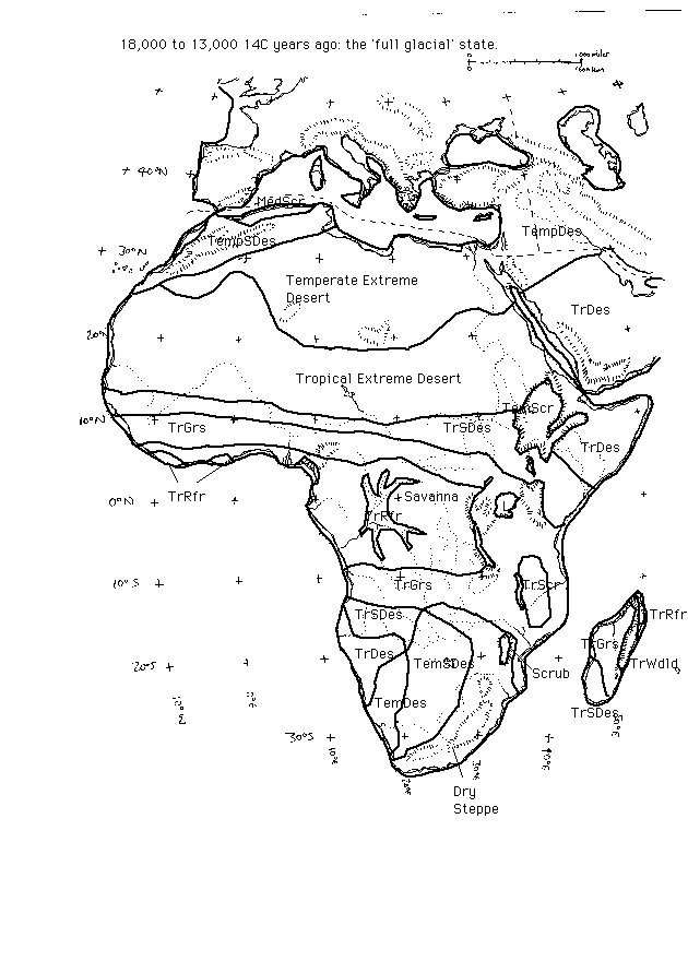
Last Glacial Aridity Maximum/Maxima 22-13,000 14C y.a. (about 23,000-14,500 'real' years ago). This map is based upon the reconstructions previously drawn for the Last Glacial Maximum (18,000 14C y.a.) drawn on the basis of diverse sources of evidence summarized in the main QEN review. Note that the LGM itself may have been a slightly moister phase (though still very arid) separating two extremely arid phases. The maps here are intended to represent the peak arid conditions across Africa.
Aridity, and to a lesser extent cooling, are the major features of Africa during the full glacial period. Ancient sand dune distributions suggest that the Sahara desert zone extended hundreds of kilometres further south than at present, compressing the other vegetation and climate zones equatorwards (Thorp 1994). However, in a restricted area of the north-west Sahara, greater winter rainfall seems to given moister conditions, with a belt of semi-desert appearing to the south of the present-day desert margin (Hooghiemstra et al. 1992).
There is considerable geomorphological, zoological and palaeobotanical evidence for a major rainforest retreat during this time, with its place being taken by savanna and grassland vegetation in most (but not all) areas (Maley 1988, Dupont 1988, Caratini & Giresse 1979, Giresse et al. 1990, Jahns 1995, Preuss 1992, Van neer 1984, Tamura 1990, Runge 1995). The fragmented forest areas that remained in this region contained a significant proportion of montane trees, suggesting that lowland tropical mean temperatures were around 5-6 deg.C cooler than at present (Maley 1989, Livingstone 1993). However, the actual position and extent of forested refugial areas is still controversial due to the sparsity of evidence.
Quite extensive studies of stony layers and other geomorphological/sedimentological features by Runge, strongly suggest that savanna-open woodland type climates (too dry to support forest vegetation) were predominant in the eastern Congo Basin between 30,000 and 11,000 14C y.a. (Runge 1992, 1996, 1997). He suggests that the annual rainfall in the eastern Congo Basin around the LGM 1000mm, with a seasonal climate with rainy and dry seasons and high potential for erosional activity; forests would have been confined mainly to strips of 'gallery forest' along rivers. Compared to the present-day rainfall of 2000-2400mm this means a reduction by about 1000-1400mm for the LGM (not allowing for temperature lowering). Runge's findings are summarized in this web site (written in German). The eastern part of the Basin at present contains some of the moistest tropical forest climates in the region, and the finding suggests a simultaneous elimination of forest from most of the Congo Basin during the LGM period.
The view that there was a major reduction in forest in all parts of equatorial Africa at around the LGM has been reinforced by the results of 5 pollen sites by Jolly et al. (J. Biogeog. 1997, v.24 p.495-512) from the highlands along the eastern edge of the Rift Valley (the other side of the valley from the rim of the Congo Basin), which show a dry grassland and ericaceous scrub vegetation in areas that presently support moist forest. This area had previously been thought likely to have acted as a moist forest refugium against aridity, because of its very high present-day rainfall; yet even this area turns out to have been too arid for forest at that time. As Moore (1998) points out, the forest flora in these areas must have been surviving only in very localised patches of forest, perhaps along river courses.
In eastern and southern Africa, the general picture is of greater aridity and also a cooling of several degrees in mean annual temperature (Taylor 1992). Stokes et al. (1997) have studied ancient linear dunes in northern Botswana and SE Namibia, using uranium/thorium and quartz optical dating. They find evidence of extensive last glacial dune formation across the area between about 19 and 17 deg.S, 24-25 deg.E, close to the Zambezi River. It appears that extreme desert conditions were widespread in this area, which presently receives almost 800mm rainfall and has a scrub and woodland vegetation. The detailed timing of desert episodes in the area is somewhat uncertain; major episodes of dune activity are suggested as having occurred 26,000-20,000 'real' years ago (that is, about 30,000-17,000 14C years ago), with a slight decrease in dune activity (but still desert conditions) after this to be followed by a second maximum 16,000-10,000 'real' years ago (about 14,000-9,000 14C y.a.). Whether this second episode includes a 'Younger Dryas' (11,000-10,000 14C y.a.) episode of aridity as well as a late-glacial one is not clear, though the fairly wide error limits in the dates do not preclude it.
Partridge (1997) has reconstructed LGM rainfall isohyets over southern Africa for the LGM, on the basis of various sources of evidence combined. He suggests that annual precipitation in SW Zambia and SE Angola (about 13-15 deg.S) was no more than 20% of present values (about 150mm or less, compared to the present 800-900mm), with extreme desert and extensive dune mobility. Most of SW Africa seems to have had rainfall about 50% of present values, enough to give widespread desert, with a broad zone of the most extreme desert (under 100mm annual rainfall) extending eastwards just to the north of the Cape zone. The SE of the region is suggested as having higher values, about 60-70% of present-day. It is not clear whether these reconstructed values take account of temperature change.
There are indications from various parts of Africa (central and eastern Africa) and also Arabia that the maximum aridity may have occurred slightly after the global LGM, at around 17,000-15,000 14C years ago, although the LGM itself seems to have been generally much more arid than present (Adamson et al. 1980, Gasse 1975). Plankton indicators of upwelling intensity off the coast of Somalia suggest that the summer monsoon (which supplies much of northern, east and central Africa with its rainfall) seems to have been substantially weaker than present at the LGM, but reaching its weakest at around 15,800 - 12,500 14C years ago, that is 17,800-13,800 calibrated or 'real' years ago (Zooneveld et al. 1997).
Signs of a slight moistening of climate and temperature rise in have been noted the the pollen records of central and east Africa around 14,000 14C y.a. (Hamilton 1988). For example, montane forest began to spread in high elevation areas of east Africa around 14,000 14C years ago. (Vincens 1991, Taylor 1992). It has been suggested that the earlier change was especially noticable at high altitudes was because a temperature increase occurred before the main precipitation increase, and that the high altitude vegetation was more limited by temperature than drought (Zonneveld et al. 1997). In the Negev, moister-than-present conditions around 13,000 14C y.a. are registered by development of a palaeosoil of that age (Goodfriend & Magaritz 1988). In southern Africa, the onset of moister post-LGM conditions may have been delayed, with some indications of extensive dune activity continuing in northern Botswana, although this may be due to ambiguity in the dating of aridity which actually occurred slightly earlier, or later during the Younger Dryas (Stokes et al. 1997).
Africa under full glacial conditions - 22,000-14,000 14C ya
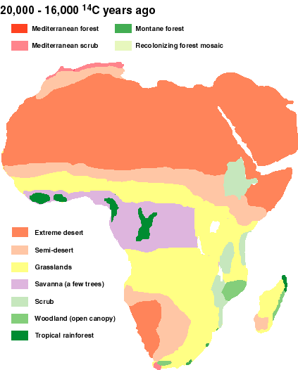 Africa under full glacial conditions
In east Africa, very moist conditions caused the overflow of Lake Victoria northwards into the Nile at about 12,500 - 11,500 14C y.a. (Paulisson 1989). Again, this might also have reflected a lack of vegetation cover (allowing greater runoff) rather than much higher-than-present rainfall, although this is uncertain. However, montane forest in the mountains had not yet returned, perhaps to lags in ecological succession processes (Hamilton 1988). In Malawi, a river channel cutting stage that is interpreted as the result of moister conditions begins around 12,000 14C y.a. (work by Meadows 1985, cited in Thomas & Thorp 1992).
Southern Africa's climate remained slightly cooler than today, although warmer than before, with drier-than-present summers. In the Highveld uplands, a shrubby grassland (with arid fynbos elements) remained predominant, with occasional stands of Podocarpus indicating cooler-than-present conditions. At Wonderkrater (Scott & Thackeray 1987) pollen cores suggest cooler but slightly moister than present conditions, with upland ericaceous elements within the grassland.
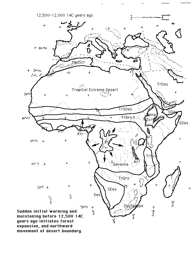
Africa at around beginning of interglacial-type conditions - 12,500-12,000 14C ya
Rainfall in the watersheds of the White Nile seems to have been particularly high about 11,500-11,000 14C y.a., resulting in high river discharge (Williams 1995).
In east Africa, moist montane forest had returned by around 11,000 14C y.a. (Hamilton 1988), though the forest had returned to higher-altitude parts of its range by this time, at lower altitudes in the east African mountains it took until 10,000 14C y.a. to reappear (Moore 1998).
Climatic conditions may have been particulartly unstable during the general period between 12,000 and 11,000 14C y.a.; cores indicating monsoon strength off the coast of Somalia (Zonneveld et al. 1997) suggest large and rapid variations in monsoon strength that may well have given rise to intensly wet and arid phases in short succession across much of Africa. The instability culminated in the 'Younger Dryas' monsoon failiure discussed below.
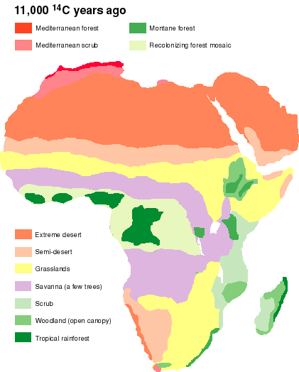
Africa just before the Younger Dryas - 11,000 14C ya(IN COLOUR) Africa just before the Younger Dryas - 11,000 14C ya
It is possible that parts of southern Africa were also affected. Linear dunes may have reactivated in the area north of the Orange River (Steven Stokes pers. comm. Feb '96), and at least some dates for dune activity in northern Botswana seem to fall within this age range (Stokes et al. 1997), suggesting that there may have been quite extreme desert conditions in the area at that time. However, there is a considerable error range in the dates obtained from the optical dating methods used, so the dune activity might potentially have been a couple of thousand years before, or perhaps even slightly after, the Younger Dryas. Probably the best case for it being Younger Dryas in age is that it correlates with a general pattern of events seen elsewhere. Younger Dryas cooling has been found from the Atlantic coast, from isotopic variations in shells (Cohen et al. 1992), and Partridge (1997) reports unpublished work on ostrich eggshell isotopes which suggest a similar picture inland in southern Africa.
Indicators off the coast of east Africa suggest that very pronounced weakening of the summer monsoon system occurred at this time, corresponding to the scattered indicators of aridity (Zonneveld et al. 1997), and indirectly suggesting that the aridity may have affected all areas of Africa that get most of their rainfall from the summer rains. The strength of the monsoon intensity at this time was similar to what it had been during the general period of the Last Glacial Maximum, but not as low as it had reached during the weakest phase between 14,000 and 12,500 14C years ago.
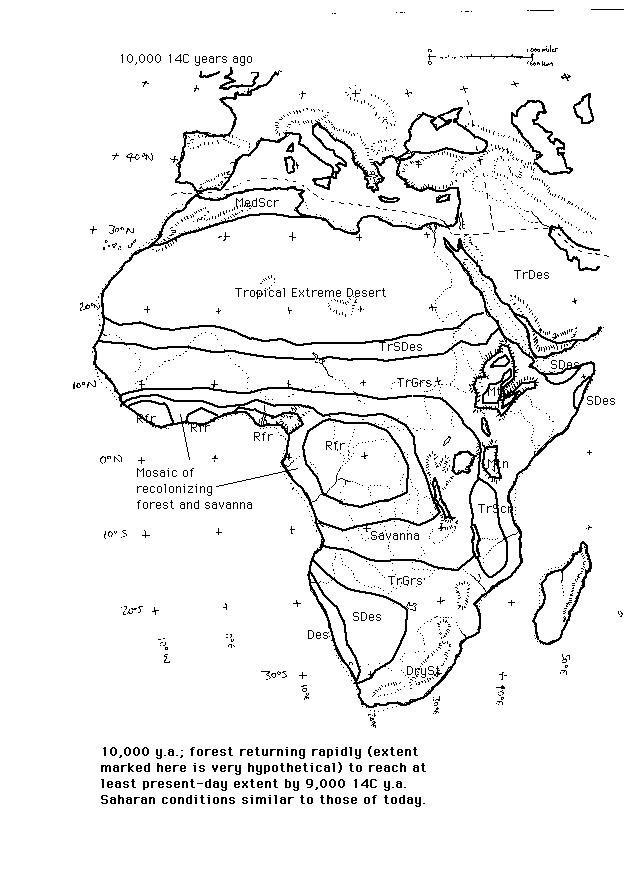
10,000 14C y.a. After the Younger Dryas, conditions became moister. The vegetation zones of the Sahara seem to have lain in similar positions to those of the present-day (Lezine 1989), although Thomas & Thorp suggest from the level of Lake Chad that conditions were moister-than-present at around 10,000 14C y.a. Forest in central Africa continued to return, reaching the equivalent of its present range and density about 9,500 14C y.a. (Hamilton 1988).
Africa just after the Younger Dryas - 10,000 14C ya
Recent summary of evidence from Sahara and northern China suggests strong fluctuations in aridity all across the monsoon belt.
Guo et al. (2000) have published a review of evidence of Holocene moist and arid phases across the Sahara and north-western China. For the Sahara, 560 14C dates were used, from such sources as lake and swamp sediments, freshwater molluscs and diatoms. For northern China 158 14C dates were used, from palaeosols and surface water sediments.
Guo et al. note that their review reveals repeated and roughly synchronous arid phases punctuating the much moister-than-present conditions across the monsoon belt. From the scatter of radiocarbon dates, there are evidently some gaps making precise delineation of the arid phases difficult. The relative 'severity' of the arid phases between these two regions also differs; in China the arid events seem more severe and they often bring the climate to conditions more arid than at present, whereas in the Sahara most of the 'arid' events were still much moister than present-day conditions. Indeed, for both the Sahara and China the timing and duration of arid phases from the summary diagram given by Guo et al. differs somewhat from those they describe in the text of the paper. Based on the text of the paper the following arid phases seem to have occurred during the Holocene, interrupting the moister-than-present climates with conditions more similar to or even drier than those at present. It is likely that further refinement of the timing of these arid phases will occur as more data are gathered in the literature. By implication, other parts of the monsoon belt (e.g. India, Arabia) that have not been studied in such detail would also have experienced changes similar to those found in the Sahara and China.
SAHARA (dates in Guo et al are given in 14C years ago on the left, approximate calibrated of 'real' dates are given on the right)
Moist 9,500-8,200 14C ya (10,400-9,100 ya)
Slight drying 8,200-8,000 14C ya (9,100-8,900 ya)
Moist 8,000-7,000 14C ya (8,900-7,900 ya)
Moderately dry 7,000-5,700 14C ya (7,900-6,500 ya)
Moist 5,700-4,000 14C ya (6,500-4,500 ya)
Very dry - as dry as at present - 4,000-3,800 14C ya (4,500-4,100 ya)
Slightly moister than present 3,800-3,500 14C ya (4,100-3,700 ya)
After 3,500 14C ya (3,700 ya). Remaining about as dry as at present
NORTH-WESTERN CHINA (left-hand dates in 14C years ago, right hand dates are calibrated of 'real' years ago)
Drier than present 9,000-8,500 14C ya (9,900-9,400 ya)
Moist 8,500-7,000 14C ya (9,400-7,900 ya)
Drier than present 7,000-5,600 14C ya (7,900-6,500 ya)
Moist 5,600-4,000 14C ya (6,500-4,900 ya)
Drier than present about 4,000 14C ya (4,900 ya)
Moist to 3,000 14C ya (3,200 ya)
Relatively dry phase (but still moister than present) 3,000-2,500 14C ya (3,200-2,800 ya)
Since 2,500 14C ya (2,800 ya), about the same as at present
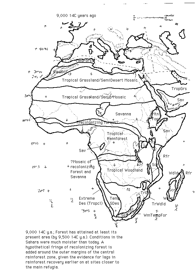
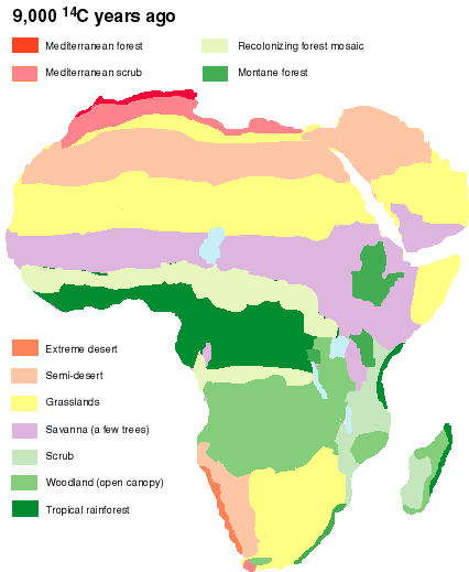
9,000 14C y.a. (about 10,000 'real' years ago).By this time, conditions in north and central Africa had become much moister than at present. The Sahara desert had virtually disappeared under a mixture of semi-arid and seasonal vegetation types (Lezine 1989, Ritchie 1994). Sapropel (organic-rich mud) layers in the eastern Mediterranean suggest maximum precipitation and freshwater discharge by the Nile between 9,000 and 8,000 14C y.a.
Arabia also experienced much higher than present monsoon rains at about this time. A pluvial episode in east and central Saudi Arabia is recorded from the occurrence of piedmont outwash gravels (Al-Sajari & Zoetl 1978), with a similar picture in the west (Whitney 1983).
In equatorial Africa, data from S. Ghana, W. Cameroon, the Congo Basin and Gulf of Guinea show that forest had reached at least its present-natural extent and full cover before 9,000 14C y.a. (Hamilton 1988). In east Africa, maximum Holocene moisture levels recorded in the pollen record and as high lake levels were attained by about this time (Street-Perrott & Perrott 1994).
In East Africa, maximum rainfall/woodland cover on the west shore of Lake Tanganiyka seems to have occurred around 9,000 14Cy.a. (Vincens 1991).
Africa during the early Holocene - 9,000 14C ya
(IN COLOUR) Africa during the early Holocene - 9,000 14C ya
It is almost beyond doubt that there was an expanded area of the central and west African rainforest areas at this time. Schwartz (1991) has found soil isotope evidence that areas now covered by savanna in central Africa were forest at this time, and a forest expansion south of the Equator is supported by the pollen evidence of Elenga et al. (1993), which shows that the present forest-savanna mosaics were more heavily forested. The generally northward movement of monsoon rains into the Sahara region can be expected to have resulted in a northward expansion of rainforest as well, and this does appear to be the case from the pollen record (Lézine & Vernaud-Grazzini 1994). A conjectural boundary for the rainforest zone is drawn here.
Forest and woodland areas in the rift valley region of east Africa also seem to have been more extensive around this time (Vincens 1991, Maitima 1993).
A severe arid phase (correlated in many places around the world) seems to have affected North Africa around 7,500 14C y.a. (Alley et al. 1997, Gasse & van Campo 1994), perhaps lasting for a century or two. There was a reduction in Nile flooding, in NW Sudan lake levels, and at sites in the western Sahara, the Sahel and sub-equatorial Africa (Gasse & Van Campo 1984, Lario et al. 1997).
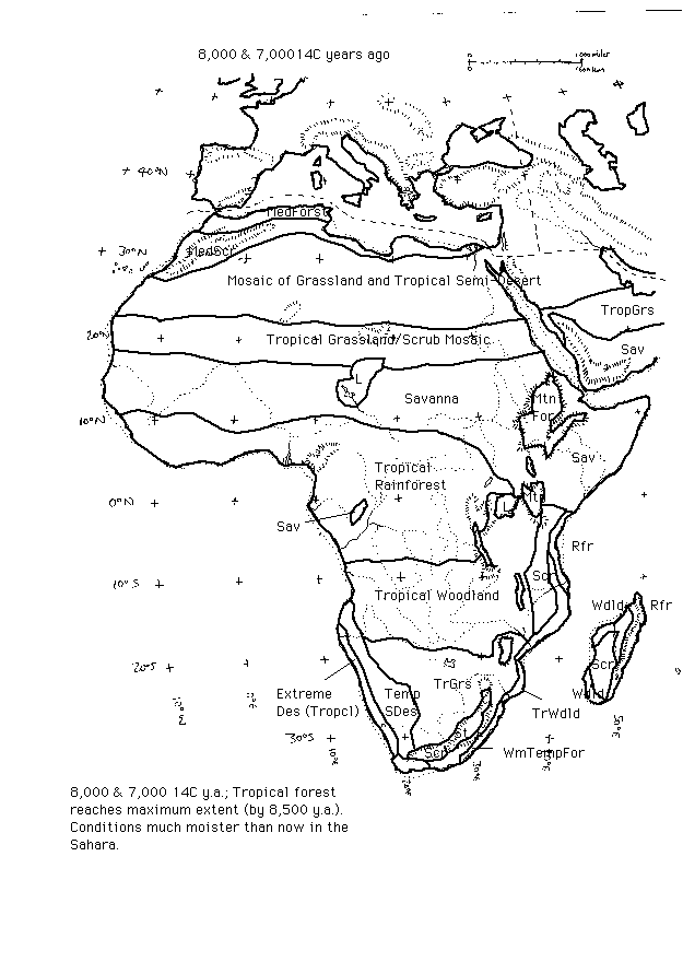
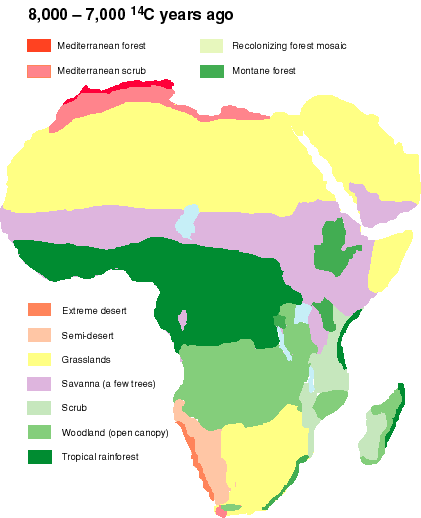
Africa during the early-to-mid Holocene - 8,000 - 7,000 14C ya
(IN COLOUR) Africa during the early-to-mid Holocene - 8,000 - 7,000 14C ya
6,500-5,000 14C y.a. Conditions across northern, central and east Africa became somewhat drier than before, but were still moister than today. For example, on the basis of pollen and charcoal, Neumann et al. (1995) suggest a mixture of semi-desert and denser scrub and grassland for the western Sahara, in areas that are now extremely arid. A similar picture is obtained by Ritchie (1994) on the basis of pollen evidence, and by Lario et al. (1997) for the Blue Nile on the basis of sedimentological and zoological indicators.
Conditions across the Sahara region and the Arabian Peninsula at 6,00014C y.a. have been summarized in a 1-degree database and set of biome maps presented by Hoelzmann et al. (1998), using pollen and charcoal data. Their map suggests a picture that is in essence similar to that given in the maps below; note however that from their useage of categories for the present-actual map, their category of 'steppe' appears to correspond to 'semi-desert' in the QEN vegetation scheme, and their 'savanna' corresponds more closely to the QEN 'grasslands' and 'scrub'. Hoezelmann et al. also suggest a very extensive area of wetlands south-east of Lake Mega-Chad, rivalling the lake itself in scale; they suggest that at 6,000 14C y.a., rainfall in the catchment area was around 300-350mm higher than today in order to sustain this high water level. Other extensive wetland areas are suggested for the interior of the eastern Arabian Peninsula. The map reconstructions of Hoelzmann et al for 6,000 14C y.a. are downloadable from this link
East Africa may also have been moister than at present, though drier than it had been during earlier stages of the Holocene (Hamilton 1982, Maitima 1991).
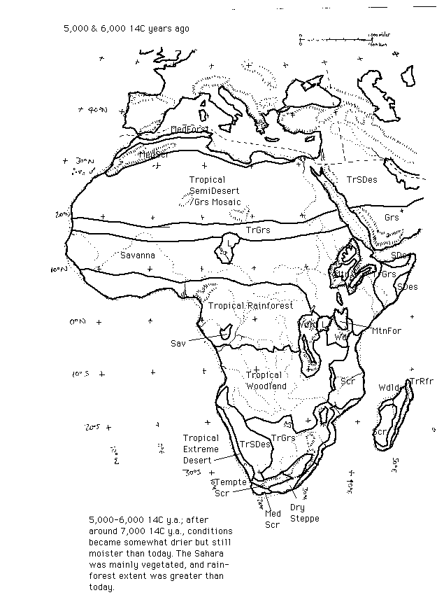
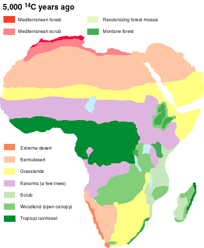
There may also have been a temporary return of moisture conditions and lake levels to early-Holocene conditions at around 5,500 - 5,000 14C y.a. (Petit-Maire & Gua 1996), for which period the map given here may not give enough moist-climate vegetation (maps for 8,000-7,000 14C y.a. could be more representative for this phase). Throughout the period 6,500-5,000 14C y.a., the Sahara was mainly vegetated (Lezine 1989, Ritchie 1994), and rainforest extent was greater than today (Hamilton 1988, and see main QEN review for 5,000 14C y.a. timeslice).
After about 5,000 14C y.a., lake levels suggest that aridity in north Africa became more severe, culminating in an arid phase about 3,800 14C y.a., a part-way return to moist conditions 4,000-3,000 14C y.a., and a decline to aridity thereafter (Petit-Maire & Gua 1996).
Africa during the mid Holocene - 6,000-5,000 14C ya
(IN COLOUR) Africa during the mid Holocene - 6,000-5,000 14C ya