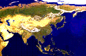
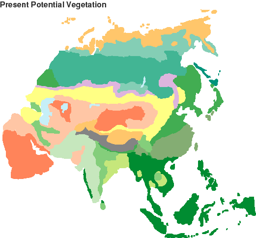
 Eurasia present-potential vegetation
Warmest phase of the Eemian interglacial, sometime between 130,000 and 120,000 y.a. (Isotope Stage 5e). For this period, data from across Siberia and central Asia are quite sparse, but they are widespread and include most regions (Frenzel et al. 1992). Frenzel et al. suggest that the warmest phase of this period was around 120,000-125,000 y.a., but in fact it was probably a few thousand years earlier judging by other attempts to date the onset of the Eemian. The general ice core chronology from Antarctica suggests that peak global early Eemian warmth may have been around 130,000-125,000 years ago, with a gradual cooling to more similar-to-present conditions afterwards (the dating of the peak interglacial deposits is subject to considerable error this far back in time). In fact, loess sedimentological changes suggest that an intense cold, dry event affected central China at around 121,000 years ago, before a reversion to conditions similar to the present (Zhisheng & Porter 1997), with another similar event (not showing up in the north Atlantic records) at around 113,000 y.a.
In general though, before about 120,000 y.a. the plant fossil record suggests conditions warmer and moister than present, at least in the mid and northern latitudes for which good data exist. All of Siberia north of about 45 deg.N seems to have been at least 2-3 degrees warmer in summer and in winter (Frenzel et al. 1992). The greatest warming was in areas along the northern coast of Siberia, where both summer and winter temperatures were at least 5 and possibly 8-10 deg.C warmer (Frenzel et al. 1992). The plant fossil record also suggests that all or part of this warm phase was moister than present across much of Siberia and central Asia, with annual precipitation at least 100mm higher than present across the Asian desert belt, and 50-200mm higher across central and northern Siberia.
Heinrich events across Eurasia. About 110,000 - 70,000 years ago, a series of intense, cold and arid events seem to have occurred in central China (indicated by changes in loess sedimentology, reflecting an extension of the central Asian desert zone), at about the same time as Heinrich-type events in the North Atlantic and the Greenland ice core. These occurred at about 110,000 106,000 101,000 91,000 83,000 75,000 and 70,000 y.a. (Zhisheng & Porter 1997), and seem to reflect a coherant climate pattern of sudden cold and arid events extending across Eurasia.
70,000-55,000 14C y.a. Stage 4 Glacial Maximum. Globally, for example from ice core data from both poles, this cold stage resembled the Last Glacial Maximum/Stage 2 (below), but little specific evidence is available for Eurasia. Snowline (in the mountains of Japan) and dust flux data (from deep sea cores taken off the coast of Japan) suggest a climate with a cold, dry summer dominated by winter monsoonal precipitation throughout Japan (Ono & Naruse 1997). Comparison of snowlines and dust flux suggests that the climate of Japan during Stage 2 was somewhat drier than during this Stage 4 glaciation (Ono & Naruse 1997).
55,000-30,000 14C y.a. Roughly corresponding to Stage 3 (highly variable 'middling' period). The Siberian jay was quite recently reported from a fossil fauna in a cave in the central Asian Altai mountains from Marine Isotope Stage 3, suggesting that there were reasonably large areas of taiga vegetation in these mountains during at least parts of this period (Burchak-Abramovich & Burchak, in press). The fauna from the Altai site is very similar to what would be expected to occur today in the same area, at a rather higher altitude (near the treeline).
In China there are a few faunal localities from this period. These suggest that for much of the time, northern China was cold/dry steppe during the last glaciation (e.g. the extinct ostrich Struthio anderssoni). In southern China, 'montane' forest mammals and birds of Western China occurred in the lowlands (e. g. the bird Tragopan temminckii well east of its present range in Sichuan, and also Great Pandas). These suggest cooler but fairly moist conditions at least part of the time (Tyberg pers. comm. 1998).
30,000-25,000 14C y.a. During this period, at least some wooded or perhaps forest vegetation existed across central Siberia, as woody plant fossils are found in the Ineisei Valley (Drozdov et al. 1995).
In Taiwan, pollen evidence indicates that vegetation was more open than present - though wooded - under drier and cooler than present conditions (Liew et al 1998). After 25,000 14C y.a., conditions became still drier (with dry winters) and cooler.
LGM and late Glacial 18,000-14,000 14C y.a. Conditions all across northern Eurasia appear to have been dry and treeless, dominated by polar desert or semi-desertic steppe-tundra. There are many sources of evidence supporting this interpretation; where pollen can be recovered it shows a high proportion of plants of open ground, and the 'buried soils' themselves show chemical and morphological indicators of arid conditions, together with such 'desert' features as windblown sands, wind-sculpted pebbles, wind-eroded hollows, and the sediments of intermittant desert lakes (Spasskaya 1992). The very lack of animal fossils or organic sedimentation of any sort from most of northern Eurasia during this period further suggests aridity.
Pollen and morphological evidence suggests that winter (February) temperatures across southern Siberia were about 12 Deg.C lower than at present (Frenzel 1992a), giving winters almost as severe as those in north-eastern Siberia at present. In the coldest parts of north-eastern Siberia, Frenzel suggests winter that temperatures were some 12-14 degrees lower even than the present extreme temperatures. Summer temperatures for August (Frenzel 1992b) are reconstructed as being about 6 deg.C lower throughout Siberia and the central Asian desert region, except in the north-west close to the ice sheet where they may have been 8-10 deg.C lower than today.
In southern Siberia, the survival of semi-desert mammals suggests somewhat less severe aridity, but with conditions colder than today's (see the main QEN review for a detailed discussion of the evidence relating to this zone during the full glacial period). Relatively moist, but still more arid than present, conditions may have prevailed in some parts of north-eastern Siberia on the continental shelf, and adjacent lowland areas where rain-bearing winds could pentrate inland from the ocean. Whatever the conditions in the lowlands, the high topography of most of eastern Siberia would have meant polar/montane desert conditions in the colder climates of the last glacial. Note that the available evidence, in the view of virtually all those who work on this area, from most of Siberia strongly contradicts the reconstructions based on GCM models by Prentice et al. (1993) and the palaeoevidence-based vegetation reconstructions of Van Campo et al. (1993) and Peng et al. (1995), in which substantial areas of forest are shown across southern Siberia, and the treeless zone to the north was assumed to be a 'moist tundra' or 'moist steppe' type of environment with high biomass and productivity and deep organic-rich soils.
Large ice-dammed lakes appear to have been present in the west Siberian basin throughout the full glacial period (Velichko and Kurenkova 1990). The actual size of these lakes is still uncertain, but in fact they may have been linked into one very large lake that covered almost all of the basin, as this unpublished manuscript suggests. Lower sea levels exposed extensive land bridges in south-east Asia and across Beringia to Alaska. The large amount of data relating to palaeoenvironments for this period is summarized in the main text of the QEN review.
In both tropical and temperate southern Asia, a range of sources (including a number of pollen diagrams) suggest that conditions were also much drier and colder than now, with regression of forests and expanded areas of desert. In northeast China, a semi-desert steppe-tundra seems to have predominated (Wang & Sun 1994), grading in to forest-steppe further south. In the present cool temperate latitudes of Japan (linked to the mainland as a single peninsula), there were large areas of grassland or forest-steppe combined with an open cool temperate/boreal deciduous woodland cover (e.g. Pinus, Quercus, Betula), grading northwards into open boreal woodland (with extensive grassy openings) dominated by Larch (Larix) and Spruce (Picea) on the present northern-most island of Hokkaido (Igarishi 1996).
Even in the present warm temperate and subtropical latitudes of southern China (between 20 and 31 deg.N) and Taiwan, there seems to have been a substantial forest regression. Reviewing the pollen evidence at several pollen sites scattered through SE China and Taiwan (e.g. Min River Delta 26 deg.N, Pearl River Delta 23 deg.N), Liew et al. (1998) conclude that grasslands predominated in lowland areas, with cool temperate forest and open woodlands in upland areas at least in the east. On the Leizhou Peninsula in southernmost China (20 deg.N), which presently has a very moist (about 2000mm annual rainfall), warm climate and paratropical rainforest, at the LGM a relatively northerly warm temperate pine/oak forest or woodland was present. Here, there signs of more arid than present conditions; pollen of grasses and open-ground ferns among the trees indicating incomplete canopy cover, and coarser sedimentary grades and hiatuses indicative of drier conditions.
Liew et al. (1998) note that even in places in eastern China and Taiwan where tree cover was predominant at the LGM, from the presence of abundant grass and open-ground pollen and spore types, it seems to have been fairly open (perhaps more a 'woodland') in those areas. They suggest that lowering of annual precipitation across the region was at least 1000mm relative to the present. Liew et al. show a present-day annual precipitation map of southern China (p.93); It is interesting to note that two pollen sites which were apparently steppe at the LGM (Pearl River at about 23 deg.N, and Ningbo Plain at 26 Deg.N) have present precipitation above 1400 mm, but evidence of long-distant transport of tree pollen from uplands receiving about 1600mm or more. If we extrapolate this relationship across southern China-Taiwan for the LGM, with all areas with less than 1600mm present rainfall being steppe, and those above 1600mm being forest or open woodland, most of southern China would be steppe, with areas of wooded vegetation in isolated uplands covering about a third of the region. An site far inland to the west in the upper Yangtze region also shows pollen evidence of open pine woodland at the LGM in an area with present precipitation above 1600mm (Sun 1990). If the '1600mm' pattern holds true, it would give an LGM vegetation distribution in which about 2/3 to 4/5 of China between 30 and 20 Deg.N would have been steppe vegetation, with most of the rest (on scattered upland areas) as open woodland. Even this may be a conservative estimate in favour of woodland cover; mid and low altitude sites on Taiwan with annual rainfall above 2000mm also seem to have lost their forest cover at the LGM.
Winkler & Wang (1993) already suggest a belt of 'forest and grassland' across southern-most China (about 20-23 deg.N) at the LGM, but from the evidence summarized by Liew et al, it seems necessary to conclude that the LGM vegetation map of Winkler & Wang (1993) shows too much forest in other parts of the south-eastern China/Taiwan region.
The southern (presently warm temperate) part of Japan seems to have had at best a rather open cool-temperate or even boreal-type woodland in most areas (Ooi et al. 1990, Ooi 1992). Mean annual temperature in SW Japan seems to have been about 7-9 Deg.C lower and precipitation was less than 1/3 of present values (Yasuda 1990).
The climate across Indian and south Asia generally seems to have been much more arid than present. Geomorphological indicators from the landmass of India suggest dune mobility in the north-west (Bryason & Swain 1981), and greatly reduced river flow in north-central India during the span of time that covered the full glacial (Williams & Clarke 1984). Offshore indicators of salinity (due to runoff from the land) suggest that LGM aridity was substantially greater than at present. Indicators of upwelling intensity in the Indian Ocean suggest that the summer monsoon was much weaker than present at the LGM, but reaching its weakest at around 15,800 - 12,500 14C years ago, that is 17,800-13,800 calibrated or 'real' years ago (Zonneveld et al. 1997).
In the rainforest zone of Indo-China and Indonesia, there are signs that aridity greatly reduced the forest cover during this period. Although forest cover in the tropical mountains of Indonesia remained intact (though with a 1000m-lower treeline due to cooling) (Stuijts et al. 1988), at a lower elevation site on Java that now receives abundant rainfall, the rainforest vegetation was reduced to dry scrub (S. van der Kaars & R. Dam ). There are also various rather poorly dated indicators of loss of forest cover and savanna or scrub expansion elsewhere in the region. The only relatively well-dated site from Thailand (Loeffler et al. 1984) suggests greatly reduced river flows and sand-dune activity in the dry seasonal river beds. MS submitted for publication 1994). It is possible that a decrease in rainfall occurred at higher elevations, but the rainfall is so great there anyway that the decrease produced almost no change in the vegetation. Lowered sea levels would have exposed a large landmass, linking most of islands of the region. It is likely that aridity in the centre of the landmass - due to isolation from moist ocean winds - would have given a dry grassland or scrub vegetation.
In eastern and central Turkey, high lake levels at the LGM - 18,000 14C y.a. - existed at the same time as arid steppe-like vegetation (Landmann et al. 1997), perhaps due to storms occurring mainly during the winter season when vegetation would have been dormant and unable to take advantage of the moisture (Prentice et al. 1992).
There are signs that conditions around 17,000-15,000 14C years ago were the aridity peak in several areas of Eurasia, for example in Yunnan Province of the extreme SW of China (Liu 1991), where the local warm temperate forest (which had apparently survived in situ through the 18,000 14C y.a. LGM itself) disappeared from the site and was replaced by dry scrub at about this time, due to a weakening of both the summer and winter monsoon rains. Sea upwelling indicators south of India suggest that the summer monsoon was weakest around 15,800 - 12,500 14C y.a., and allowing for possible uncertainties in dating, this may produce an overlapping period of late glacial extreme aridity in Eurasia. The lake level record from Turkey suggests that the most arid period was also around 16,000-15,000 14C y.a. (Landmann et al. 1997). At this time, it seems, both the winter (Liu 1991, Landmann et al. 1997) and summer (Zonneveld et al) rains were especially weak across southern Asia.
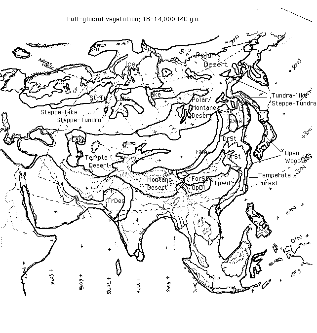
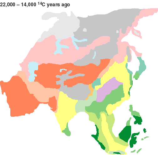 Eurasia during most extreme part of full glacial conditions
(17,000-15,000 14C y.a.).
Eurasia during most extreme part of full glacial conditions
(17,000-15,000 14C y.a.).
This map concentrates on the time window slightly after the LGM, when aridity seems to have reached its most extreme point. Only slightly moister conditions prevailed for most of the period 22,000-14,000 14C y.a. (25,000-15,000 calendar years ago). A large area of extreme desert conditions existed across central Asia (dark red), surrounded by semi-desert (light red), under conditions much colder than the present-day. In the north, Siberia was colder and much more arid, with steppe-tundra (pink) and polar desert (grey). Ice masses (light grey) were present in north-western Siberia. In China, colder more arid conditions caused a retreat of forests, with grasslands (yellow) and open woodlands (medium green) in southern China and Japan. Forest steppe (violet) and conifer forest (blue green) may have predominated elsewhere. In south Asia, rainforest (darkest green) retreated and was replaced by grasslands (yellow) and monsoon forests and woodlands (lime-green). Scrub and open woodland (lighest green) probably existed in presently moist forest climates of Bangladesh and SW China.
Eurasia under full glacial conditions - 22,000-14,000 14C ya
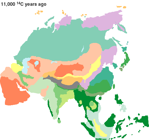
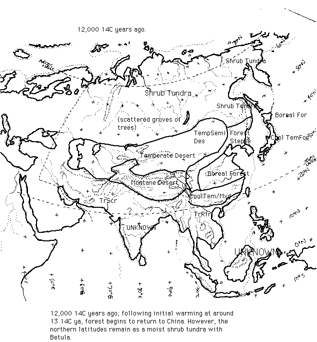
12,000-11,000 14C y.a. There appears to have been an initial moistening and warming of climate across Eurasia at about 13,000 14C y.a. (e.g. Gupta 1988, Lozhkin et al 1993, Velichko 1995).
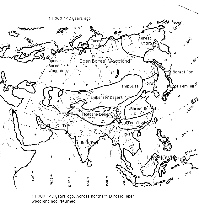
In north-east Eurasia, and possibly elsewhere in northern Eurasia, an initial cover of shrub tundra replaced the polar desert at about this time (Lozkin et al. 1995), to be followed by open steppe-woodlands by about 12,000 14C y.a. (Kreminsetski 1995, Velichko 1993) (map 2a). The woody cover increased up until about 11,000 14C y.a., by which time most of Siberia was covered by open woodlands of birch and boreal conifers (Velichko 1993). The map 2b here depicts the situation more at 11,000 14C y.a.
At a site near Semipalatinsk (50 deg.N, 80 deg.E) on the southern fringes of the present-day taiga belt in central Asia, trees (Betula, Larix, Picea) began to return to the landscape after the end of the full-glacial cold and aridity around 13,000 14C y.a., although dry steppe vegetation with chenopods and Artemisia remained predominant (Tarasov et al. 1997).
In south-east Eurasia, two lake records in central and eastern Turkey suggest that conditions were moister than during the glacial period, but still drier than today (Landmann et al. 1997).
On the northern Japanese island of Hokkaido, connected by the north to the Siberian mainland up until 10,000 14C y.a., a boreal forest cover began to return at about this time (Igarishi 1996). A peak of larch (Larix) abundance and a sharp decrease of Sphagnum has been taken by Igarashi (1996) to indicate a major cool and arid event around 12,400 - 11,800 14C years ago (January temperatures 9 deg.C lower, July temperatures 7 deg.C lower, and annual precipitation around 735 mm less than today). It is not clear to what extent this might actually correspond to the Younger Dryas event (see below), due to some form of inaccuracy in the dating, or whether it represents a quite discrete cooling event (perhaps related to the Older Dryas of Europe, for instance).
In central and northern China, climates may have been colder than todays'. A cover of cold climate conifers had returned by about 12,000 years ago (Liu 1988), in areas now occupied by cool temperate forest. Cool temperate forest also existed as a belt in southern China, well to the south of its present distribution.
From the Bay of Bengal, there are indications that monsoon runoff at 11,500 14C y.a. was in fact greater than today (Cullen 1980), suggesting that rainfall over southern Asia was especially intense (through runoff may also have been aided by the slowness of vegetation recovery).
Eurasia following the onset of interglacial warming- 12,00014C ya
 Eurasia just before the Younger Dryas
Eurasia just before the Younger Dryas - 11,000 14C ya
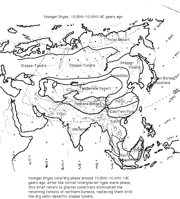
Younger Dryas 11,200-10,200 14C y.a. Across all or most of northern Eurasia, this phase seems to have been marked by strong cooling and aridity with complete disappearance of the woodlands and forests that had been present before (Velichko 1993, Kreminetski 1995). Conditions reverted almost to their full-glacial state, with semi-desertic steppe-tundra prevailing, and tree cover confined to an open parkland surviving in river valleys in Siberia.
In China, the forest cover also seems to have retreated. In the north, near Beijing, conditions returned to semi-desert much as they had been during the last glacial (Lu et al. 1995). A core from a lake in Mongolia at the present margins of the Gobi Desert also suggests substantially colder and more arid than present conditions across central Eurasia during the Younger Dryas. In central China, the predominant vegetation seems to have been forest steppe, with patches of temperate and boreal trees surviving on hillslopes (Zhou 1992, An et al. 1993). In south-west China, there are indications of a cold, dry phase at about the same time, although the area apparently remained forested (Jarvis 1993).
New high resolution cores of environmental indicators from the desert-loess transition zone in NW China suggest that the cold and dry conditions of the Younger Dryas may have been punctuated by a return to warmer, humid conditions for several hundred years between 10,600 and 10,200 14C y.a., followed by a return to the cold and dry conditions from 10,200 to 10,000 14C y.a (Zhou et al. 1996). This pattern is apparently not pronounced elsewhere, although Zhou et al. note that some slight amelioration of the cold conditions during the middle Younger Dryas is noted in records from the Norweigen Sea area of the NE Atlantic, and Anderson (1997) suggests a somewhat similar pattern of most extreme conditions at the beginning of the Younger Dryas followed by a slight amelioration in NW Scotland.
There seems to be little information that specifically relates to the period from elsewhere in Asia. In the mountains of central Japan, glacial moraines have been suggested to show a glacial advance at roughly the time of the Younger Dryas (Aoki 1994). A major cold and dry event in the pollen record on the northern Japanese island of Hokkaido (Igarashi 1996) might perhaps correspond in time with the Younger Dryas, although Igarishi dates it to slightly earlier in the Late Glacial (see above). In tropical south-east Asia, reductions in sediment flow suggest that forest recovery may have continued unabated in Kalimantan (Thomas & Thorp 1990). Further evidence that the Younger Dryas was unimportant at tropical latitudes in south-east Asia comes from sea surface temperature records from a core in the South China Sea. There is no indication from the plankton assemblages of conditions any different from present, during the Younger Dryas (Thunell & Miao 1996).
However, in south-western Asia - in central Turkey and in the Zagros Mountains of eastern Turkey - new correlations of pollen diagrams and a lake level record (lake Van) suggest that during the Younger Dryas, conditions returned to aridity as severe as that reached during the aridity maximum around 17,000-15,000 14C years ago (Roberts & Wright 1993, Landmann et al. 1993), and possibly even more severe (Rossignol-Strick 1995). Younger Dryas conditions were not so extreme everywhere in this region; at Abu Hureya, in the Eurphrates headwaters in northern Syria, trees become much less common, annual flood levels along the river decreased greatly, and dry steppe plants predominated, but the area was not apparently reduced to desert. A similar move to a dry steppe vegetation is seen in moister sites in the Jordan Valley to the south, for example at Lake Huleh (Wright 1993, Fagan 1995). Around the end of the Younger Dryas (before or after the sudden warming event that ended this dry phase?), about 10,000 14C y.a., cereal agriculture began at Jericho in the Jordan Valley (Wright 1993).
Eurasia during the Younger Dryas (THIS MAP IS CURRENTLY UNDERGOING REFURBISHMENT)
A return to cold, dry conditions destroyed the open woodland cover that had previously spread across Siberia, replacing it with polar desert in the highlands and far north (grey) and dry open steppe-tundra (pink) across most of the region. The only other area for which there is substantial discussion is China, where forest cover (darker greens) retreated but was not eliminated. Forest steppe came south into central China, due to the cooler and drier conditions, and the desert zone of central Asia extended eastwards (light and dark red). In tropical south-east Asia, the Younger Dryas seems to have had much less effect; for example on Borneo, forest cover seems to have continued increasing during the Younger Dryas. Other areas of southern Asia seem to have been drier than present too. Note that present-day coastlines are used here, in the absence of available Younger Dryas coastline reconstructions.
Eurasia during the Younger Dryas - 11,000-10,200 14C ya
Recent summary of evidence from Sahara and northern China suggests strong fluctuations in aridity all across the monsoon belt.
Guo et al. (2000) have published a review of evidence of Holocene moist and arid phases across the Sahara and north-western China. For the Sahara, 560 14C dates were used, from such sources as lake and swamp sediments, freshwater molluscs and diatoms. For northern China 158 14C dates were used, from palaeosols and surface water sediments.
Guo et al. note that their review reveals repeated and roughly synchronous arid phases punctuating the much moister-than-present conditions across the monsoon belt. From the scatter of radiocarbon dates, there are evidently some gaps making precise delineation of the arid phases difficult. The relative 'severity' of the arid phases between these two regions also differs; in China the arid events seem more severe and they often bring the climate to conditions more arid than at present, whereas in the Sahara most of the 'arid' events were still much moister than present-day conditions. Indeed, for both the Sahara and China the timing and duration of arid phases from the summary diagram given by Guo et al. differs somewhat from those they describe in the text of the paper. Based on the text of the paper the following arid phases seem to have occurred during the Holocene, interrupting the moister-than-present climates with conditions more similar to or even drier than those at present. It is likely that further refinement of the timing of these arid phases will occur as more data are gathered in the literature. By implication, other parts of the monsoon belt (e.g. India, Arabia) that have not been studied in such detail would also have experienced changes similar to those found in the Sahara and China.
NORTH-WESTERN CHINA (left-hand dates in 14C years ago, right hand dates are calibrated of 'real' years ago)
Drier than present 9,000-8,500 14C ya (9,900-9,400 ya)
Moist 8,500-7,000 14C ya (9,400-7,900 ya)
Drier than present 7,000-5,600 14C ya (7,900-6,500 ya)
Moist 5,600-4,000 14C ya (6,500-4,900 ya)
Drier than present about 4,000 14C ya (4,900 ya)
Moist to 3,000 14C ya (3,200 ya)
Relatively dry phase (but still moister than present) 3,000-2,500 14C ya (3,200-2,800 ya)
Since 2,500 14C ya (2,800 ya), about the same as at present
SAHARA (dates in Guo et al are given in 14C years ago on the left, approximate calibrated of 'real' dates are given on the right)
Moist 9,500-8,200 14C ya (10,400-9,100 ya)
Slight drying 8,200-8,000 14C ya (9,100-8,900 ya)
Moist 8,000-7,000 14C ya (8,900-7,900 ya)
Moderately dry 7,000-5,700 14C ya (7,900-6,500 ya)
Moist 5,700-4,000 14C ya (6,500-4,500 ya)
Very dry - as dry as at present - 4,000-3,800 14C ya (4,500-4,100 ya)
Slightly moister than present 3,800-3,500 14C ya (4,100-3,700 ya)
After 3,700 14C ya. Remaining about as dry as at present
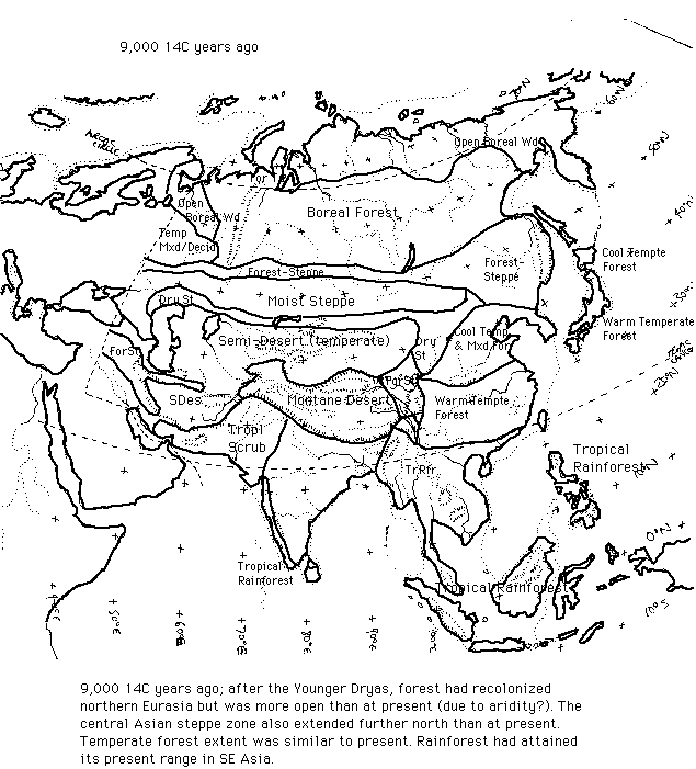
9,000 14C y.a. early Holocene. Following a sudden warming and moistening of climate around 10,000 14C years ago, tree cover quickly returned to northern Eurasia. By around 9,000 14C y.a., pollen cores suggest that open birch forest was widespread across western Siberia (Khotinsky, in Velichko 1993, Kreminetski 1995), with open mixed temperate forest immediately west of the Urals (Peterson 1993). The central Asian steppe and forest-steppe zone seems to have extended further north than at present. In the far north, forest reached the Arctic coasts by about 9,000 14C y.a., due to a warmer-than-present climate.
Tarasov et al. (1997) suggest that the open forest-steppe that had predominated near Semelpalatinsk at the southern edge of the present Siberian taiga zone since 13,000 14C y.a., and disappeared at around 10,100 14C y.a., being replaced by open steppe with grasses and Artemisia. Open forest, in the form of birch (betula) and later pine (Pinus) did not spread across this area until around 7,800-6,800 14C y.a.
In northern and central China, Winkler & Wang's (1993) map based on various pollen cores suggests that a forest cover returned shortly after 10,000 14C y.a., and that the vegetation zones were shifted slightly northwards relative to the present, due to a warmer climate. Vegetation also extended westwards into the present arid belt due to greater rainfall. A similar situation of fairly warm, moist conditions seems to have existed at the 9,000 y.a. timeslice that is mapped here (Zhou 1992, Winkler & Wang 1993), although the peak Holocene warmth and moisture had not yet been reached. The record of paleosol formation in north-west China similarly suggests that peak Holocene moisture conditions had not yet been reached (Petit-Maire & Gua 1996).
Liew et al. (1998) find pollen evidence for a brief cool event around 8,500 14C y.a. (about 9,500 'real' years ago), with an abrupt increase in cooler-climate trees. This might perhaps correspond to the 1500-year cycle of cold events found in many other parts of the world (a widespread cold event has been found for about 8,000-8,200 'real' years ago, though it apparently does not show up in the Taiwanese pollen record).
Eurasia during the early Holocene - 9,000 14C ya
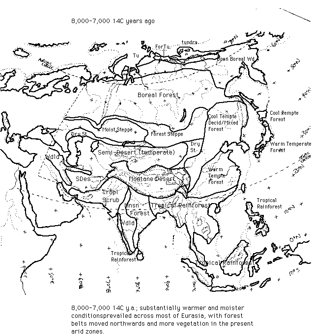
8,000-7,000 14C y.a. By 8,000 14C y.a., forests in most areas of northern Eurasia were at least as thickly wooded as they naturally would be today. Conditions remained considerably warmer and moister than at present, with much greater vegetation cover in desert regions, northward extension of warm temperate forest belts in China and Japan (Winkler & Wang 1993, Petit-Maire & Gua 1996). There was probably greater forest extent in south Asia due to a stronger summer monsoon in India (suggested by both land-based and oceanic indicators of monsoon strength in the region; e.g. Cullen 1981, Zonneveld et al. 1987) and in Indo-China (e.g. Bishop & Godley 1994). Evidence from this time interval is discussed in detail on the main QEN review.
Eurasia during the early-to-mid Holocene - 8,000-7,000 14C ya
6,000-5,000 14C y.a. Plant fossil and sedimentological evidence suggests that conditions remained moister and warmer than at present, with forest vegetation exceeding its present limits in most parts of Eurasia (Winkler & Wang 1993). Lake level evidence from widely scattered areas across Eurasia (western Siberia, Mongolia, Yakutia and China) also suggests moister than present conditions at this time (Harrison et al. 1996). Petit-Maire & Gua (1996) suggest that the paleosol record in north-west China indicates a relatively arid phase 6,500-5,500 14C years ago, though with a return to peak Holocene humid conditions 5,500-3,800 14C y.a. .
Evidence from this time interval is discussed in detail on the QEN web page.
Klimanov (1992) has reconstructed February temperatures for the interval 6,000-5,50 14C y.a., based upon a range of biological and geomorphological indicators. He suggests that all of Siberia had winters at least 1 deg.C milder, with central Siberia being 2-3 deg.C milder. August temperatures from central Siberia northwards are also suggested as having been at least 1 degree higher, with a warming of 2-4 degrees along much of the northern coast of Siberia (Klimanov et al. 1992).
Since 5,000 14C y.a.
There are some signs of a cool, moist event around 2,600 14C y.a. leading to an increase in peat growth in northern Japan. This seems to correlate with a near-global cool event (van Geel et al. 1996).
Another cold phase is recorded from about 1,400 y.a., (about 536 A.D.) lasting two to three years. Documentary evidence from the time details that frosts and snow occurred in China, leading to crop failiure and famine (Baillie 1994). This event also shows up strongly in tree growth rings from western Europe (Baillie 1994), and coincides with records from the Greenland ice cores, the Mediterranean, and the south-western USA showing either fairly direct evidence of cold conditions, or famines. The most likely cause is a volcanic dust layer, which shows up in the ice core records (Baillie 1994).