
| This web site now resides at http://geoecho.snu.ac.kr/nerc.html. Please change your bookmarks. |
Visit my Memories of Tennessee photo gallery
Global land environments since the last interglacial
For a colour LGM global ecosystem summary map click here.
An atlas of the ice age Earth
The following ecosystems maps, compiled by Jonathan Adams, were
last edited in 2002. They are preserved online here as a resource
for scientists and the general public. The maps and text are not
copyrighted, but please cite this Web site as described at the base
of this page.
References cited on the QEN pages, including those cited here
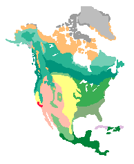
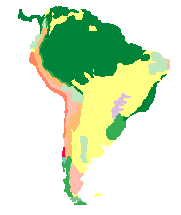
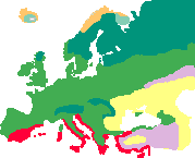 Europe
Key to the vegetation classification system used in the atlas
The main QEN Home Page (a more detailed literature review of the LGM and early-to-mid Holocene)
The procedure for constructing the regional maps
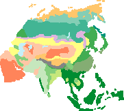
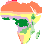
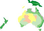
The maps presented here are based on inter-disciplinary interpretation of evidence from plant fossils, together with zoological evidence, soil and sedimentological analyses which also have some bearing on vegetation cover. The approach has been to review current literature and liase with experts from each region (acknowledged within the text). Given the scope of the task, regional review sources and published maps have been an important source of information, with less emphasis placed on consulting every published paper on each region (of which there are many thousands). In many areas, the evidence is sparsely distributed and the map reconstructions presented here should only be regarded as tentative. Summaries of the evidence from each region are presented, in order to give some impression of the quality of data currently available, and the present disagreements within the literature. It is to be expected that as further evidence accumulates over the coming years, significant revisions to these maps will become necessary.
Brief discussion of the differences between various published palaeovegetation maps
More detailed description of the mapping process
Other pages in this series, dealing with past environments
Link to QEN pages, a more detailed, extensive literature survey of the world since the last glacial maximum
Sudden climate transitions during the past 130,000 years (heavy version) (now published in Progress in Physical Geography January 1999) or easy reading version
A quick background to the Pliocene
The onset of Northern Hemisphere glaciation
A Siberian mega-lake at the Last Glacial Maximum
Carbon storage in ecosystems; past, present and future
Discussion of the differences between various published palaeovegetation maps
Biogeography and geological history of tropical rainforests
Did Indo-European
languages spread before farming? (in press; Current Anthropology)
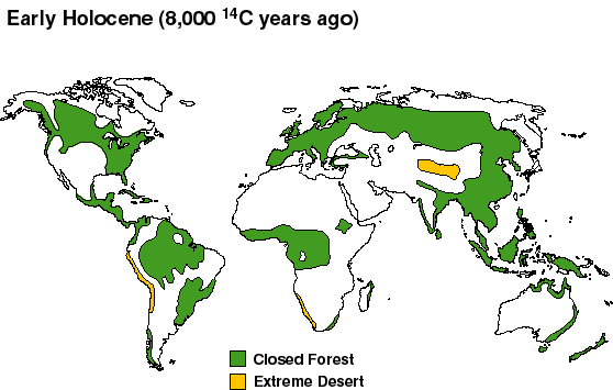
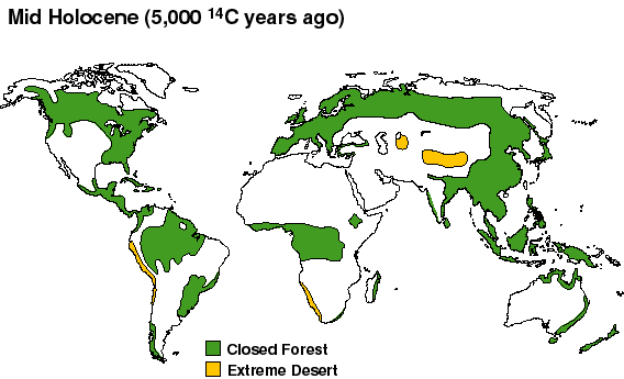
Summary maps of forest and desert cover
The four maps below provide a rough guideline to the general changes in vegetation cover that have occurred since the Last Glacial Maximum. They are roughly drawn and not intended as a reference source (the more detailed regional maps on these web pages will provide you with a much more accurate guide to the likely palaeovegetation cover). They are merely a brief introduction to show how the world changed. It is evident that for 18,000 14C years ago the area of the most extreme deserts was much greater than in either the present day world or the other two Holocene time slices. For the early and mid-Holocene, in contrast, extreme desert almost disappeared due to much moister climates.
During the arid LGM and the several thousand years that followed it, forest cover was also greatly reduced due to a mixture of cold and aridity. Closed forests were almost non-existent in Europe and Siberia, and tropical forest seems to have been confined by aridity to what are presently the highest rainfall areas. The early-to-mid Holocene (8,000 & 5,000 BP) had greater forest cover due to higher rainfall in many parts of the world, and slightly warmer temperatures in the high latitudes and at high altitudes.
This is not the only set of maps that have been put together for the last 20,000 years. This linked page discusses the differences between various published palaeovegetation maps
Last Glacial Maximum vegetation
Summary map of vegetation cover at 18,000 14C years BP. This
map illustrates the aridity of full-glacial conditions suggested on the
basis of palaeoevidence from around the world; there was much less closed
forest and more desert than at present. In fact, current evidence from
various parts of the world suggests that the greatest overall aridity was
reached slightly after 18,000 14C y.a., and closer to 16,000-14,000 BP.
In this sense, the map may be more appropriate as a representation of conditions
slightly after the LGM. Nevertheless, the whole period from about 21,000-
14,000 14C y.a. seems to have experienced much colder and more arid conditions
than at present.
Colour
LGM global ecosystem summary map.
Summary map of vegetation cover at 8,000 14C years BP. By 8,000 14C y.a., the Earth was under a full interglacial climate, with conditions warmer and moister than present in many parts of the world. Tropical forest in Africa (and probably also Asia) was expanded in area, and the areas of desert in Africa and Asia were much reduced.
Summary map of vegetation cover at 5,000 14C years BP. Generally, conditions remained similar to those in the 8,000 y.a. slice, though with some reduction in the African and Asian monsoon rains.
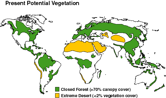
Summary map of 'present potential' vegetation cover. This map
is for purposes of comparison, showing the areas of forest and other desert
that would be present in the present-day world if humans had not altered
them by agriculture and forestry. Although it represents a 'potential'
state, it is nevertheless much as the world would actually have looked
about 4,000-3,000 14C y.a., before agriculture became important in modifying
vegetation cover in many regions.
Present
potential global ecosystem summary map.
When citing this page in the literature, please use the following format;
Adams J.M. (1997). Global land environments since the last interglacial. Oak Ridge National Laboratory, TN, USA. http://www.esd.ornl.gov/ern/qen/nerc.html
And for the QEN site (the older and more extensive literature review dealing with three time slices during the last 18,000 14C years), use the following format;
Adams J.M. & Faure H. (1997) (eds.), QEN members. Review and Atlas of Palaeovegetation: Preliminary land ecosystem maps of the world since the Last Glacial Maximum. Oak Ridge National Laboratory, TN, USA. http://www.esd.ornl.gov/ern/qen/adams1.html