Summary
From around 150,000 to 130,000 years ago, North America experienced colder and generally more arid than present conditions. About 130,000 years ago, a warm phase slightly moister than the present began, and conditions at least as warm as the present lasted until about 115,000 years ago. Subsequent cooling and drying of the climate led to a cold, arid maximum about 70,000 years ago, followed by a slight moderation of climate with a second aridity maximum around 22,000-13,000 14C years ago. Conditions then quickly became warmer and moister, though with an interruption by cold and aridity in many areas around 11,000 14C years ago.
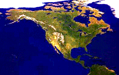
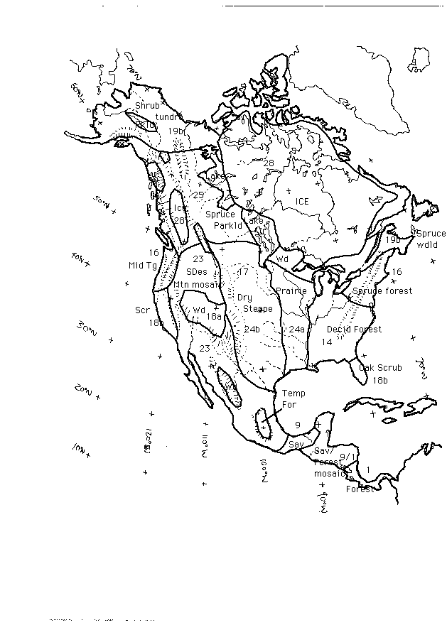
This, roughly speaking, is the vegetation cover that existed 500 years ago as Europeans began to arrive in the Americas. In the eastern USA, forest was predominant with warmth-adapted temperate forest in the south-east. To the west, decreased rainfall and the resulting fires prevented trees from growing, and a wide grassland belt (prairie) existed. In the mountains and plains of the far west, sparse rainfall gave semi-desert, open scrub and open conifer woodlands. To the north, various conifer forest belts extended across Canada, opening out into the meadow-like tundra where climates were too cold for trees to grow.
130,000-125,000 y.a. Eemian 'optimum', Isotope Stage 5e. Data for this period are in short supply. Frenzel (1992) and Velichko et al. (1992) have only three data points for eastern USA; these suggest warmer (2-3 degC warmer) winter temperatures north of about 30 deg.N, and warmer summer temperatures north of about 45 deg.N. The annual rainfall is also suggested as being higher than present across the eastern USA. Whitlock & Bartlein (1997) suggest slightly drier and warmer conditions than present in the Cascade Range (45 deg.N) of the western Cordillera, with dry woodland at lower elevations but a strong steppe element.
115,000-100,000 y.a. Late Eemian cool stage, Isotope Stage 5c. From a site in the Cascade Range (Whitlock & Bartlein 1997), open Pinus forest predominated locally, with steppic elements also important. The climate seems to have been cooler than present, and perhaps slightly drier than present too.
40,000 14C y.a.; a fairly cold phase, in the 'middling' period between the two main glacial maxima. A map summary for the eastern USA has been compiled by Delcourt & Delcourt (1981), on the basis of a number of pollen sites and other data such as ice margin positions. Delcourt & Delcourt suggest that ice extent over eastern Canada was only slightly less that its maximum extent around 20,000 y.a., and that it extended just south of the Great Lakes. Spruce and jack pine forest seems to have covered most of the eastern USA, with mixed cool temperate forest in Tennessee and North Carolina. Southern pine forest with oak and hickory existed south of this, extending around into easternmost Texas. Open scrub is reconstructed for the Florida Peninsula.
Delcourt & Delcourt (1981) give a summary map for the eastern USA at 25,000 y.a., showing spruce and jack pine forest extending south to about the latitude of Washington DC, and thinning out into forest-steppe west of the Mississippi River. A mixed cool temperate forest belt seems to have existed across the south Appalachian region. From South Carolina southwards to northern Florida, oak-hickory and southern pine forests are suggested as having survived.
In the western cordillera of the USA, lake levels were higher than today (indicating moister conditions) but not generally as high as they would become at the LGM. In northern Arizona, altitudinal zones of vegetation had not yet declined to their LGM positions (which were reached by about 24,000 y.a.), but were lower than today. In the NW Cordillera of the USA, in eastern Cascades Range at 45 deg.N, 120 deg.E, forest cover was considerably less than today, with more steppe and cold-tolerant species (Whitlock & Bartlein 1997). This followed an earlier stage, 30,000-40,000 y.a., when there had been slightly warmer conditions in the Cascades with more forest cover (though still considerably less than today).
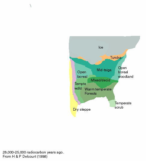 Eastern USA 28,000-25,000 14C y.a.
This vegetation map showing the eastern USA during the period 28,000-25,000 14C y.a. has been compiled by Paul & Hazel Delcourt. An ice sheet already covered most of Canada and extended south of the Great Lakes. Boreal conifer woodlands and forests predominated in what is now the cool temperate forest zone, and the cool and warm temperate forest belts were compressed southwards.
Also see main QEN section on North America
Quick-time movies of the spread of pollen types in North America over time.
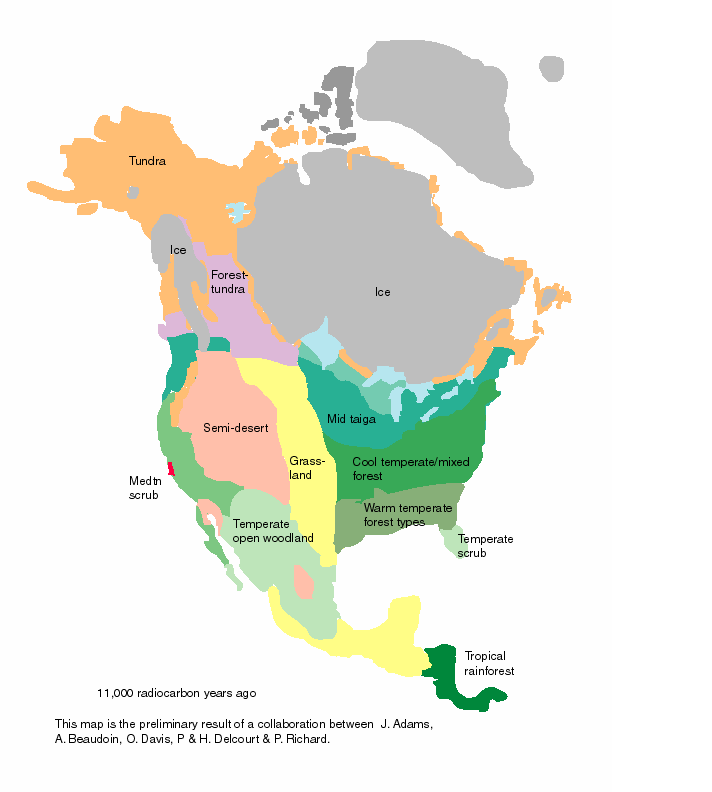
18,000-15,000 14C y.a. (about 21,000-17,000 calendar years ago). The full glacial.At this earliest mapped time slice, North America was still in the grip of full glacial conditions. The ice sheet extent did not remain static through this period; by 15,000 14C y.a., some retreat of the major North American ice mass had occurred relative to the 'global' glacial maximum position some 3,000 radiocarbon years previously (Dyke & Prest 1987), it still covered most of the continent and was even more extensive in some places. The ends of what was later to become an ice-free corridor had begun to open by 15,000 14C y.a., but about 1000 km of ice still remained blocking its course.
Lower sea levels had exposed a land bridge extending across from Alaska to the eastern tip of Siberia. Known as Beringia, this exposed land seems to have had localised areas of moist, peaty tundra (though not true 'peatland') in stream and river valleys, but other pollen cores and geomorphological indicators show that the higher slopes and knolls, and areas towards the north and away from the Pacific, would have had a large proportion of open ground (Elias et al. 1996, Colinvaux 1996). In the interior of Alaska, conditions seem to have been particularly dry and cold, and probably resembled polar desert. See the main QEN section on North America for a more detailed discussion of Beringia.
The Beringian Atlas Project is focussing on broadscale reconstruction of the environments of Beringia over the last 17,000 years (however, their maps are not yet fully available online).The Cordilleran ice sheet (curving round across southern Alaska and the Canadian Rockies) covered all of the islands along the west coast of Canada, except possibly the Queen Charlotte Islands. The linked Laurentide ice sheet covered most of eastern and central Canada. South of these combined ice masses, open woody vegetation seems to have prevailed towards the east and south of the USA.
Much of the southeastern USA was wooded or forested, almost as far north as the edge of the ice sheet. In general this forest cover seems to have been more open than today, especially on the Atlantic coastal plain, and it also thinned out westward, giving way to forest-steppe and then open dry steppe in the mid-west (present-day prairie region). This link shows what the landscape of much of Illinois may have looked like during the last glacial period. Probably, the land eastward of Illinois would have been more densely wooded than this, but still with significant open areas between the trees. To the west, the tree element would have declined to leave a dry and virtually treeless steppe.
To the east of the Appalchians, there was a high proportion of cool climate pines and often the presence of prairie herbs amongst the trees (e.g. Brook & Nickmann 1996), and on the Atlantic coastal plain there are indications of shifting sand dune activity which - together with the predominance of jack pine - suggests that the woodland was fairly open (Wells 1992). Apparent blowout structures formed along the coast from the Carolinas to Geogia ('the Carolina Bays'), due to dry conditions with rather open vegetation. The generally rather dry nature of the climate may also be reflected by the occurrence of a 'blue clay' layer (probably wind-deposited) in the Carolina Bays. See this link on the blue clays
See the QEN section on North America for references and more detailed discussion of the evidence.
In the south-east, the Florida Peninsula may have been virtually a desert of shifting dunes at some stages during the last glacial (Wells 1992), and at other times it seems to have been covered by a sparse scrub vegetation. The Gulf coastal plain and northernmost Florida seems to have been forested, with some open woodland (Watts & Stuiver 1980). The relative proportion of deciduous trees (mainly oaks) in the vegetation seems to have increased southwards. Some authors (e.g.Watts & Stuiver 1980) appear to incline more towards the view of a mixture of conifer forest and other more open types of conifer woodland dominating in all except a few localities in the southern USA. Paul & Hazel Delcourt (pers. comm., January 1998) suggest that the climate on the Gulf coastal plain would have been seasonally more dry than today, but with a more winter-wet and summer-dry pattern. The Delcourts note that summer-dry conditions would favor drought tolerant species of oaks and hickories at the expense of southern pines, so oak and hickory may have been quite common within the forests and woodlands. The Delcourts suggest that in northernmost Florida and on most of the Gulf coastal plain, the variety of full-glacial habitats would have permitted a mixture of both xeric and mesic forest communities to persist, more mixed-mesic deciduous forests in fire protected sites along river valleys and stands of temperate oaks and southern pines across sandy interfluves.
The north-western USA was dominated by dry alpine tundra and polar desert (trees were almost absent except perhaps very scattered remanants of spruce; Whitlock & Bartlein 1987), with scattered areas of cold-tolerant conifer woodland in the central Rockies (mixed with semi-desert vegetation) (See Davis' reconstruction, below). Further south in the Cordilleran region of the USA, a mixture of semi-desert scrub and sparse conifer woodland existed in a mosaic that depended on altitude (Thompson et al. 1993), with the open-conifer woodland dominating in most areas (see Davis' reconstruction).
A new (1998) map reconstruction of the western USA by Owen Davis shows temperate open woodland covering most of the southwest, and also parts of the High Plains. The view of the High Plains as woodland-covered is perhaps somewhat controversial (and he is thinking of changing it to semi-desert!), an alternative view being that it is a result of selective conifer pollen transport/preservation, in an environment which was mainly grassland at the LGM. Another divergence in opinion in the literature is Wells (1992) suggests a desert area in the northern High Plains (based on dunes etc.), in the area which Davis suggests was tundra. In the northern-most area of the NW plains, close to the Canadian border, a pollen site at Mitchell Lake suggests semi-arid conditions; regional vegetation from c. 17 960 to 16 100 BP is interpreted as an extremely cold semi-arid Artemisia steppe. (J Paleolimnology 16: 37-57, 1996). The vegetation c. 16,100 to 11,900 seems to have been an Artemisia-Betula shrubland. This link shows palaeovegetation reconstructions by T. Webb & J. Overpeck based on pollen data only, from the eastern USA. Note however that the reconstruction of deciduous forest for Florida seems unlikely given the various sources of evidence for aridity in that area.In general it seems from the pollen profiles that the climate in the eastern USA was drier than most boreal forest in Canada or Siberia exists under at present (Jackson et al. 1997). Spruce (Picea; possibly including an extinct warm temperate species) was common and may have formed dense stands in places, including the Gulf of Mexico coastal plain. Mixed in with the mainly coniferous forests, and extending quite far north, were temperate tree taxa (e.g. Juglans, Acer, Quercus, Fagus) occurring at low densities but perhaps locally abundant on moist soils (Delcourt et al. 1980, Jackson et al. 1997).
The presence of abundant spruce pollen in the mid-western USA used to be thought to indicate a major westward expansion of forest or woodland, but this is now considered to be just the effect of long-distance transport and selective preservation of tree pollen. It is now thought that densely wooded vegetation did not proceed much further west than it does at present, though open forest steppe did apparently extend over the east of the present prairie zone.
In Mexico, conditions in the highlands may have been quite similar to those existing today (Markgraf 1993), although somewhat colder and with more dry grassland (Lozano-Garcia et al. 1993). However, the tropical forests of central America seem to have been much reduced in area. Savanna predominated in the Yucatan Peninsula (Markgraf 1993), and although rainforest survived in upland parts of Panama it may have been broken up by dry scrub or deciduous forest in the drier lowlands.

At the most extreme stage of the last glaciation, most of Canada and much of the northern USA were covered by an ice sheet thousands of metres in thickness. Colder and often drier than present conditions predominated across most of the USA. The eastern deciduous and conifer forests were replaced by more open conifer woodlands with cooler-climate species of pines and a large component of spruce. The open spruce woodland and parkland extended somewhat further west than present, into what is now the prairie zone. As a result of aridity and lowering of sea level (which lowered inland water tables), much of Florida was covered by drifting sand dunes. Notably moister than present conditions occurred across much of the south-west, with open conifer woodlands and scrub common in areas that are now semi-desert.
J. Adams' reconstruction of North America during last the glacial period - 18,000-15,000 14C ya
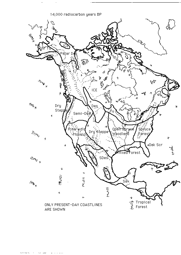
14,000 radiocarbon years ago. Indicators of a significant warming and moistening of climate begin to appear at around this time, but only in some areas. In Alaska, a widespread change from herb-dominated to moist shrub-dominated tundra occurred at around this time, suggesting moister and slightly warmer conditions (Andrews & Brubaker 1993.). A similar trend towards moister and warmer conditions is seen in the changing tundra flora and insect fauna on the eastern part of the Beringian land bridge (Elias et al. 1996).
Further retreat of the Laurentide ice sheet had occurred, but the future ice-free corridor still remained blocked by around 800 km of ice.
In the central Mexican uplands, an increase in woodlands and a reduction in grasslands after 15,000 14C y.a. suggests a switch to more humid - but still cooler - conditions than had occurred previously (Lozano-Garcia et al. 1993). Cooler conditions may have lasted up until about 9,000 y.a. (Lozano-Garcia et al. 1993).
Elsewhere in North America, conditions seem to have remained in the same dry and cold mode as before. In parts of the High Plains of the MidWest, desert conditions might have been widespread, with continuing dune activity and the absence of mammal fossils from this time (Wells 1992). However, this view is disputed by others, who suggest that instead a dry tundra environment might have been predominant towards the north (e.g. Beaudoin pers. comm. 1998).
The nature of environments in the northern High Plains/southern end of the ice-free corridor before about 12,000 14C y.a. remains uncertain, with conflicting evidence but perhaps the balance of it (from such pollen sites at Mitchell Lake) suggesting rather arid conditions, resembling semi-desert. After this stage, conditions may have become substantially moister although there are still some signs of drier-than-present conditions.
Further west, across Washington State, pollen diagrams suggest that dry and very cold conditions dominated the Cordilleran region, with a sparse parkland existing on the coastal plain and polar desert inland and at higher altitudes (Thompson et al. 1993).
Owen Davis' reconstruction for the the western USA at 14,000 14C y.a., based on plant fossil data, emphasises the more traditional (now controversial) view that woodland cover was very widespread in the High Plains areas to the east of the Rockies
J. Adams' (1996) reconstruction of North America at the time of initial warming - 14,000 14C ya
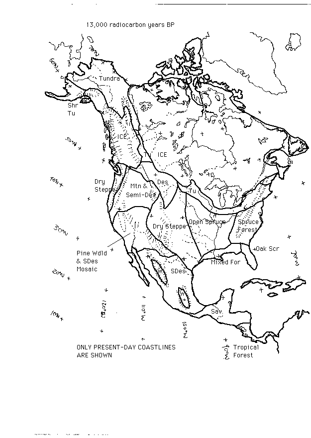
13,000 radiocarbon years ago. The vegetation distribution seems to have been much the same as at 14,000 14C years ago, though with continuing glacial retreat exposing new surfaces in North America. At around this time, according to the mapping chronology of Dyke and Prest (1987), a continuous ice-free corridor opened for the first time beween Alaska and the contiguous USA. However, for a considerable part of its length (about 750 km) it would have been less than 50 km wide, and further obstructed in several places by large meltwater lakes. The chronology of the first appearance of the ice free corridor is not completely settled however; Bobrowsky & Rutter (1992) conclude that although the southern and northern ends were open by this time, it is quite possible that the central region was still closed.
However, conditions at the southern end of the ice-free corridor (e.g. in the area around 50-52 deg.N and 110-115 deg.W, reviewed in detail by Beaudoin et al. 1996) still seem to have been fairly arid. Burns et al (1993) note the absence of radiocarbon dates on faunal remains between about 21,300 and 11,600 14C y.a. in the Edmonton area, suggesting that the landscape was incapable of supporting fauna during this interval. Beaudoin (pers. comm., January 1998) suggests - on the basis of various pollen sites - that the vegetation in southern Alberta between about 16,100 to 11,900 14C y.a. was a dry Artemisia-Betula shrubland.
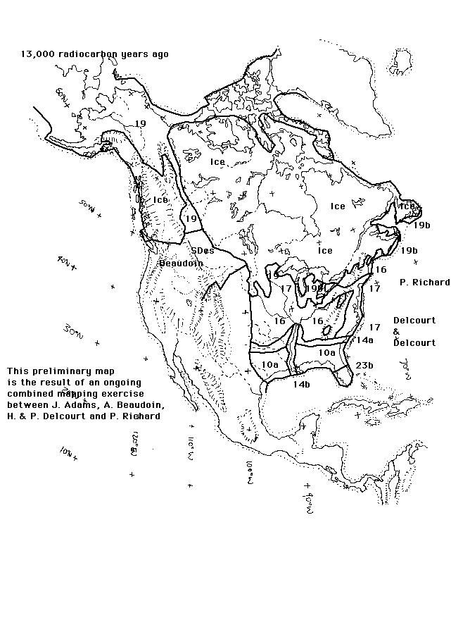
At around 13,000 14C y.a., retreat of the the western and eastern North American ice sheets exposed an 'ice free' corridor linking Alaska to the land to the south. The Bering Straits at this time also remained dry land. Cold climate conifer forest began to colonize areas exposed by the ice sheet in the eastern USA, and cool temperate forest vegetation started to spread northwards.
See Owen Davis' reconstruction (1998) of the western USA at 13,000 14C y.a.
J. Adams' (1996) reconstruction of North America during deglaciation - 13,000 14C ya
Key to the vegetation classification system used in the paleovegetation maps
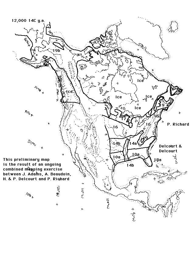
12,000 radiocarbon years ago. By around 12,000 radiocarbon years ago (Or possibly even by 13,000 14C y.a., see Davis' map above), boreal forest had spread through the western lowlands of Washington State (north-west USA), indicating the continued effects of warming and moistening of climate as the ice sheets retreated (Thompson et al. 1993, & ShowTime database). On the eastern part of the Beringian land bridge, insect communities suggest that present-day temperatures had been reached (Elias et al. 1996).
The ice-free corridor through Canada had by this time widened considerably, though it remained wholly or partly obstructed by large meltwater lakes (Dyke & Prest 1987). To the north, birch shrub-tundra had suddenly became widespread thoughout deglaciated areas of Alaska and north-west Canada.
The putative desert area which had occupied much of the the High Plains of the Midwestern USA began to show signs of moister conditions, with dune stabilization and the spread of shortgrass prairie vegetation and its associated grazing mammals (Wells 1992). At the southern and western fringes of the High Plains, pine and spruce woodland seems to have begun to spread in at around this time (Wells 1992). Davis (see map reconstruction) suggests more extensive woodland vegetation, throughout the High Plains area.
Temperate tree species began to spread and increase in abundance through the forests and open woodlands of the eastern USA, although the vegetation remained dominated by boreal conifers (Overpeck et al. 1992, ShowTime database). A map of vegetation distribution for 12,000 y.a. has been assembled by R. Webb & J. Overpeck for the eastern USA, using pollen data.
Through much of the southern and central Cordilleran area of the USA, conditions may have been slightly moister than at present (although generally semi-arid), with greater woodland and scrub cover than at present. The same appears to have been the case for the lowland American and Mexican deserts to the south (Thompson et al. 1993, Benson et al. 1997).
See Owen Davis' reconstruction (1998) of the western USA at 12,000 14C y.a., suggesting only very restricted areas of semi-desert vegetation.
J. Adams' (1996) reconstruction of North America during deglaciation - 12,000 14C ya
Key to the vegetation classification system used in the paleovegetation maps
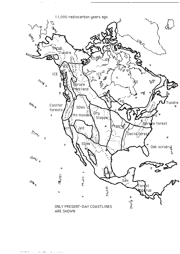
11,000 Radiocarbon years ago. The picture of climate and vegetation change at around 11,000 radiocarbon years ago is complicated by the fact that in some areas there was a cold and arid event that correlates with the 'Younger Dryas' cold event in Europe. Changes in pollen spectra from the eastern seaboard (see below), the midwest and the nw Pacific coast suggest colder, drier conditions, with a mean annual temperature decline of about 3-4 degC across these areas (Anderson 1997). A relatively dry phase in the Great Basin (comparable in aridity with the present-day)- following on from the previous initial moist phase - also corresponds in age to the Younger Dryas (Benson et al. 1997).
A significant change in forest composition occurs in the north-eastern USA (Connecticut, New York, Maine) at this time. The abundant pollen records from this area indicate a change from a mixed hardwood deciduous forest (oak, ash, spruce, fir) to a boreal assemblage (spruce, fir, larch, birch, alder). The forest canopy seems to have opened up somewhat, perhaps due to the severe winters, allowing an increase in birch and alder. In general the cooling seems to have been around 3 to 4 deg.C in mean annual temperature. See web page by Dorothy Peteet.
However in most regions of North America the Younger Dryas interval was apparently a time of continuing colonization by interglacial-type vegetation, quite unlike the major setback that it represented for European and Eurasian forests. In fact, Elias suggests that insect assemblages from the Beringian land bridge indicate summer temperatures several degrees warmer than todays' at around 11,000 14C y.a. (Elias et al. 1996), though this might hypothetically have been just before a cooling event. In contrast, preliminary results from the nearby Kodiak Island, Alaska suggest substantially colder than present vegetation conditions during the 11,000-10,000 14 y.a. interval (Peteet; see URL above).
Rising sea levels seem to have finally cut off the land bridge of Beringia sometime after 11,000 14C y.a. (rather later than was previously thought), according to recent studies by Elias et al. (1996). According to the most recent data correlation and mapping effort by the PALE group, a fairly broad swathe of land still existed across the Bering Straits around 11,000 14C y.a. Given that sea level barely rose at all during the subsequent Younger Dryas period, this landbridge would presumably have remained in place until at least 10,000 14C y.a., acting as a continuing potential conduit for human groups crossing from Siberia.
The retreating North American ice sheets had by now exposed an ice-free corridor that was some 500 km or more wide along much of its length (Dyke & Prest 1987). Animal remains start to appear at the southern end of the corridor about this time. Tree species began to colonize deglaciated parts of Canada, with conifer parkland appearing in the Rocky Mountains at about 11,000 years ago (Thompson et al. 1993). A number of pollen sites have been obtained from this general area, and the summarized 'ShowTime' pollen abundances appear to suggest that spruce (Picea) parkland was also widespread at the southern end of the ice-free corridor. However, this picture may be based on poor radiocarbon dates. In a review of the environmental history of the southern end of the corridor, Beaudoin et al. (1996) suggest that most of the vegetation was in fact non-arboreal, with birch shrubs. They note that earlier studies suggested spruce woodland already important in the landscape by this time, but that this is now in doubt because the radiocarbon-dated materials were contaminated by coal and carbonates. However, Beaudoin (pers. comm, January 1998) cites recently published evidence that vegetation in this area c. 11 900-10 200 BP was mainly or partly Picea woodland, in an environment characterized by consistently arid and windy conditions" (J Paleolimnology 16: 37-57, 1996).
Shrub tundra, and not parkland, also seems to have remained the main vegetation type across most of Alaska and in the northern part of the deglaciated corridor.
In southeastern Alaska, a short-term climate cooling between about 10,600 and 9,900 14C years ago was marked by expansion of tundra elements and deposition of inorganic sediments (Hansen & Engstrom 1996). To the south of the southern entrance to the ice-free corridor, both dune and zoological evidence suggests a temporary return of desert conditions to the High Plains of the American Midwest (Wells 1992), although the timing and relative severity of this event remains highly uncertain. The parkland and conifer woodland that had covered the eastern prairie zone during the full glacial period had by now mainly disappeared, being replaced by treeless grassland, although from the high conifer pollen percentages it seems that a band of conifer parkland may still have existed across the northern part of the prairie zone (ShowTime database).
In the eastern USA generally, deciduous forest species continued to increase in abundance throughout the 'Younger Dryas' period. In the newly deglaciated areas of the north-east, however, the predominant vegetation remained tundra and spruce parkland (ShowTime database).
 Shortly before the onset of the 'Younger Dryas' cold phase (about 11,000 14C y.a.)
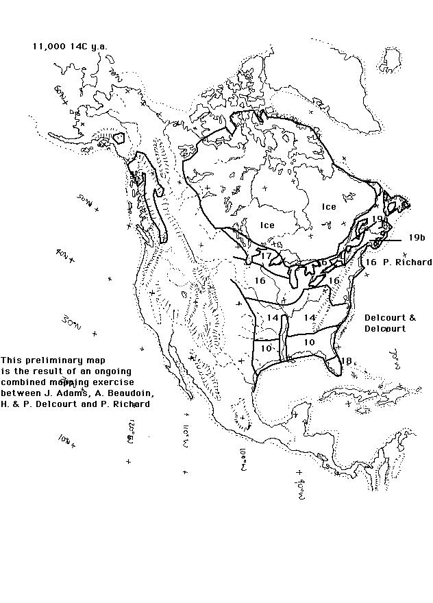
Just before the beginning of the Younger Dryas cold phase, continuing retreat of the ice sheets and recolonization of vegetation allowed conifer forests to return across the Great Lakes region. In the 'ice free corridor' of western Canada, spruce parkland (and, locally, spruce forest) had colonized. Alaska remained as tundra, and areas most recently exposed by the retreating ice were also still tundra. In the eastern USA, the cool temperate forest belt was returning, but it was generally somewhat further south than its present northern limit. Cool temperate forest had in fact reached as far as Maine in the north-eastern USA, but in this area it was eliminated and replaced by boreal forest during the subsequent Younger Dryas cold period.
See Owen Davis' reconstruction (1998) of the western USA at 11,000 14C y.a., just before the Younger Dryas cooling
J. Adams' (1996) reconstruction of North America during deglaciation- 11,000 14C ya
Key to the vegetation classification system used in the paleovegetation maps
The ice sheets of North America were by this time greatly reduced in size. Large lake systems had formed around the fringes of the Laurentide ice sheet but the retreat of the western Cordilleran ice sheet had left a broad area of lowland which was gradually becoming colonized by conifer parkland or open forest (ShowTime database). Beaudoin et al. (1996) suggest that conifer forest was present in the south-eastern foothills of the Rocky Mountains in Canada by around this time. Note that the parkland was probably much sparser towards the ice sheet margins, with a treeless zone of several hundred km resulting from lags in tree colonization in the areas exposed by the rapidly-retreating ice sheets. For example, pollen ecological studies by Ritchie in southern Canada suggest a lag of 2000 14C years at many sites between deglaciation of a site and subsequent colonization by spruce and other boreal trees.
In the western USA, such as the Owens Lake site in the Great Basin, earliest Holocene conditions may have been moister than present (with open juniper scrub vegetation replacing the open semi-desert) between about 10,000 and 9,000 14C y.a., followed by dessication to conditions similar to those of today (Benson et al. 1997).
See Owen Davis' reconstruction (1998) of the western USA at 10,000 14C y.a.. He suggests that grassland vegetation became predominant in the High Plains of the western USA about this time, replacing open conifer woodland. He suggests that up until this stage, however, open conifer vegetation may have been present across the northern High Plains
In the north-eastern USA/south-eastern Canada, colonization by trees had progressed up to the stage of giving boreal conifer forest in many areas. Deciduous tree species continued to increase in range and abundance through the eastern USA (ShowTime database).
At the north-western end of the Plains region, in Alberta, conditions may have been more slightly arid than present up until about 9,000 14C y.a. (Beaudoin pers. comm. 1998). Schweger and Hickman infer early Holocene high salinity and aridity from lakes in central Alberta and correlate these with the GCM simulations (e.g. by Kutzbach).
J. Adams' (1996) reconstruction of North America during the early Holocene- 10,000 14C ya
Key to the vegetation classification system used in the paleovegetation maps
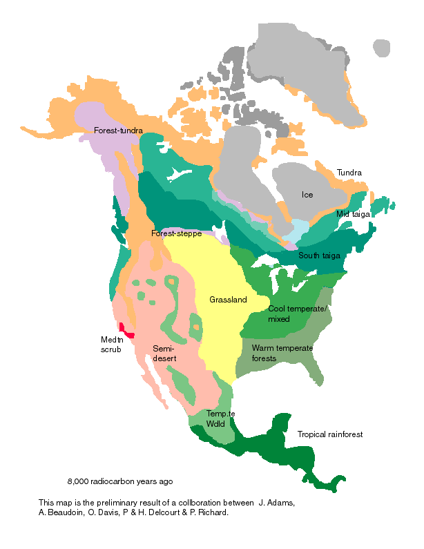
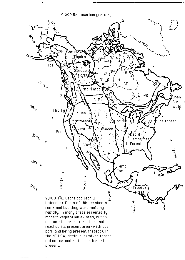
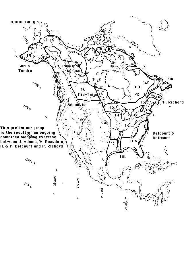
9,000 radiocarbon years ago. By 9,000 years ago, forest cover seems to have returned to many areas of North America that had been barren or covered with ice during the last glacial period. In the eastern USA, for example, the temperate forest cover had reached approximately its maximum Holocene extent (Overpeck et al., ShowTime database, Jackson et al. 1997). A map of vegetation distribution for 9,000 y.a. has been assembled by R. Webb & J. Overpeck for the eastern USA, using pollen data.
In deglaciated parts of Canada, however, open parkland remained the predominant vegetation cover (but with substantial areas of conifer forest existing within this), with relatively low tree pollen influxes and a large proportion of the pollen of steppe plants (ShowTime database). In Alaska, tundra was still the predominant vegetation type, with relatively restricted areas of spruce parkland, possibly due to relative aridity.
In the Midwest of the USA, prairie vegetation had approximately the same position as at present, through extending somewhat further north and east than during the late Holocene. Beaudoin et al. (1997) suggest that prairie extended about 80 km further north between 9,000 and 6,000 14C y.a., with records suggesting greater aridity, higher temperatures and greater salinity.
Main QEN section on North America
See Owen Davis' reconstruction (1998) of the western USA at 9,000 14C y.a. Semi-desert vegetation seems to have become much more widespread in the south-western USA at about this time.
J. Adams' (1996) reconstruction of North America during the early Holocene- 9,000 14C ya
Key to the vegetation classification system used in the paleovegetation maps
A number of pollen sites show that the prairie (grassland) zone of the central United States was expanded relatively far eastwards between 9,000 and 6,000 14C y.a. (Webb et al. 1993 Ref.). In the NE Prairie zone of Minnesota, pollen records suggest that there was a considerable expansion of the prairie around 8,800-7,800 14C y.a. (7,800-6,800 cal. y.a.) (reviewed by Dean et al. 1996). For example at the Elk Lake site, pollen-based reconstructions suggest that annual precipitation was 100mm less than today, and the mean annual temperature was warmer by up to 2 deg.C. (though ostracodes - lake invertebrates - confusingly suggest that conditions were cooler than today up until around 7,800 14C y.a. at this same site).
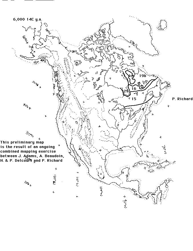
Following on from this phase, there are signs of moister conditions in central-southern Canada around 6,000 14C y.a. Apparently due to moister and cooler conditions, peat accumulation began in central Alberta about 6,000 14C y.a. (Vance et al. 1995).
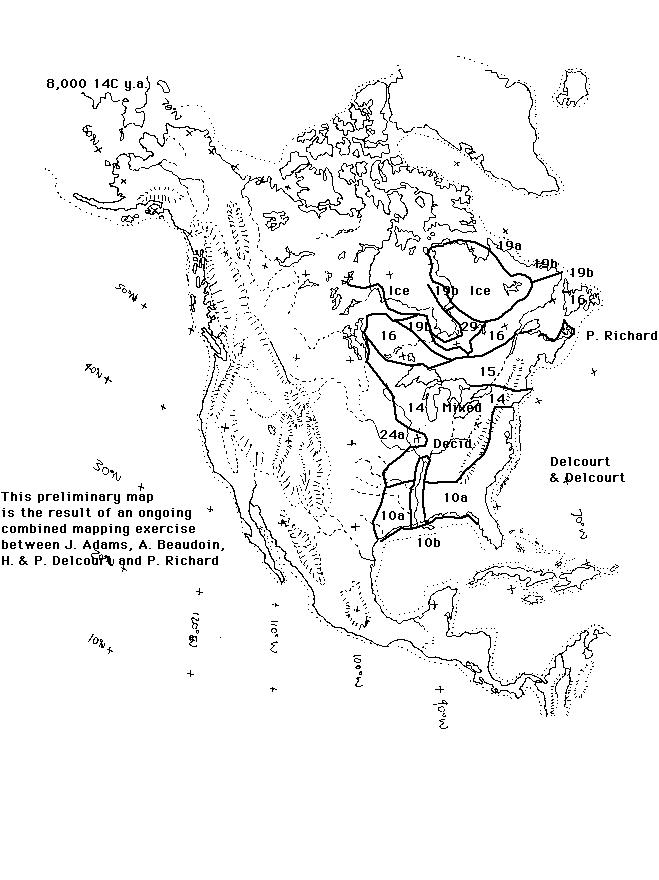
The western USA shows signs of early-to-mid Holocene warmth and dryness. Forest cover the Cascades Range of the western Cordillera of the USA was slightly greater than today (with oaks and ponderosa pine), with indicators of warmer drier conditions, between about 8,000 and 3,000 14C y.a. (9,100-3,900 cal. y.a.) (Whitlock & Bartlein 1997). After this, a slight summer cooling and increase in rainfall occurred.
Although climates were as warm or slightly warmer than at present around 8,000 14C y.a., large ice masses remained in eastern Canada because there had not yet been enough time for the ice sheet to melt away completely. Retreating rapidly and cooling the climate at their immediate periphery, the ice masses exposed a rim of new land that took time for the forest to colonize fully. In Alaska too, the present forest cover had not yet returned fully, with ongoing ecological succession. Most other areas, however, had somewhat similar vegetation cover to the present. Drier conditions in the prairie zone caused greater eastward and northward extent of the grasslands than at present.
Owen Davis' reconstruction (1998) of the western USA at 8,000 14C y.a.
Towards 3,000 14C y.a. the climate in the extreme NE of the USA/SE Canada cooled slightly to the present conditions and boreal taxa reinvaded some of their former territory in the Great Lakes and St Lawrence regions (Richard et al. 1993, Jackson et al. 1997) and in the northeastern mountains (Spear et al. 1994, Jackson et al. 1997). In the extreme north of the grassland/prairie zone, rising lake levels and decreased salinity, and a southward advance of boreal forest over prairie, all suggest moister and cooler conditions (Beaudoin et al. 1997).
Maps of vegetation distribution for 6,000 and 3,000 14C y.a. have been assembled by R. Webb & J. Overpeck for the eastern USA, using pollen data.Phases of aridity in the Mid-West grassland/prairie zones seem to have occurred sporadically during the Holocene, resulting in reactivation of dunes which had been active during the Last Glacial, for example the Sand Hills of Nebraska (Muhs et al. 1997). There seem to have been at least two very intense prehistoric droughts resulting in remobilization of the Sand Hills during the last 3,000 14C years (Muhs et al. 1997).
A rapid decline in the formerly abundant conifer known as hemlock (Tsuga) occurred throughout the north-eastern USA at around 4,000 14C y.a., with disease being a likely cause. This species has never achieved its former levels of abundance, but has recovered substantially through the north-east (Davis, l981).
A phase of cooler and wetter-than-present conditions at about 2,600 14C y.a. (2,600 y.a.) has been found for southern Quebec, and the cordillieran west of North America (evidence summarized by van Geel et al. 1996).
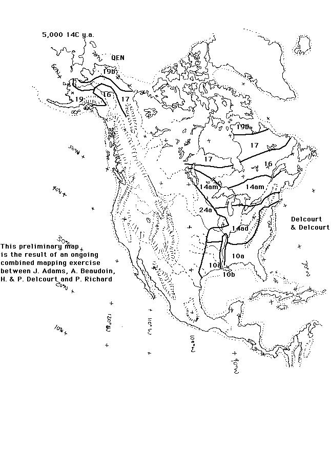
See Owen Davis' reconstruction (1998) of the western USA at 5,000 14C y.a.
Key to the vegetation classification system used in the paleovegetation maps
 Present-potential vegetation
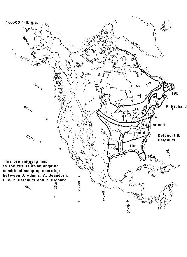
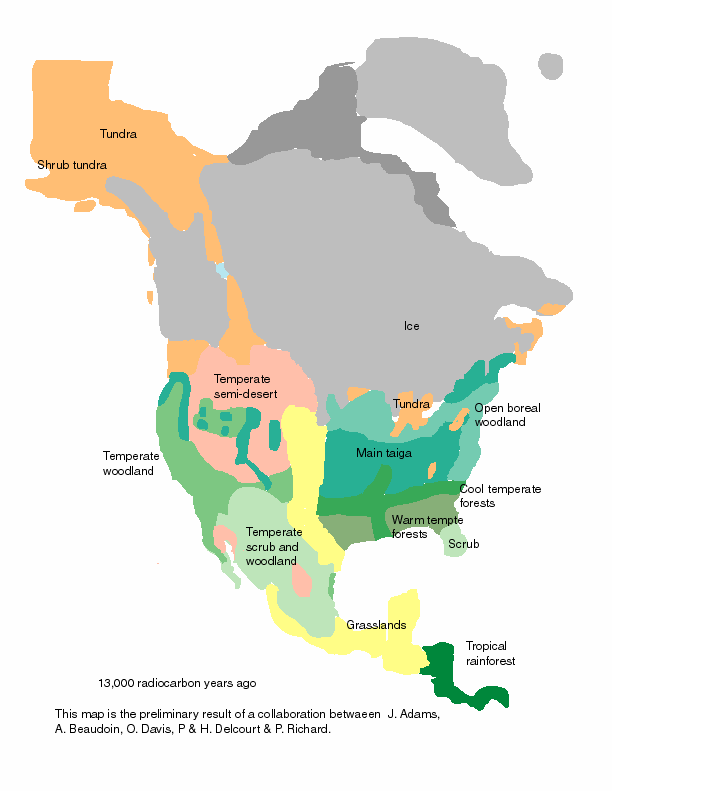 13,000 14C y.a.
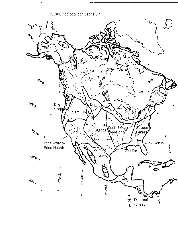